

- Usage in publication:
-
- Captain Creek limestone member
- Modifications:
-
- Original reference
- Dominant lithology:
-
- Limestone
- AAPG geologic province:
-
- Forest City basin
Summary:
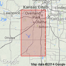
Captain Creek limestone member. Basal member of Stanton limestone and most easily recognizable unit of Lansing group in northeastern Kansas. In Johnson and Miami Counties it is gray to dark-gray, massive, evenly bedded limestone, sugary to dense. Thicknes 4.5 to 10 feet. Underlies Eudora shale member and overlies Vilas shale. Age is Late Pennsylvanian (Missouri age).
Named from stream near Eudora, Douglas Co., northeastern KS. Moore stated (1936) type locality is on Captain Creek 2 mi. east of Eudora, roadcut near southeast corner sec. 3, T. 13 S., R. 21 E.
See also Newell, 1936 (Jour. Geol., v. 44, no. 1, p. 23-31); R.C. Moore, 1936 (Kansas Geol. Survey Bull., no. 22, p. 132, 191).
Source: US geologic names lexicon (USGS Bull. 896, p. 344-345); GNC KS-NE Pennsylvanian Corr. Chart, sheet 2, Oct. 1936.
- Usage in publication:
-
- Captain Creek limestone member
- Modifications:
-
- Areal extent
Summary:
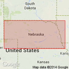
Pg. 32-33. Captain Creek limestone member of Stanton limestone. Thickness about 2 feet in Nebraska; 4.5 feet in northwestern Missouri. Age is Late Pennsylvanian (Missourian).
Source: US geologic names lexicon (USGS Bull. 1200, p. 626).

- Usage in publication:
-
- Captain Creek limestone member*
- Modifications:
-
- Overview
- AAPG geologic province:
-
- Forest City basin
Summary:
Pg. 80. Captain Creek limestone member of Stanton limestone. Dark to bluish-gray granular or dense brittle limestone; massive or even bedded; locally upper few inches is a brecciated silicified mottled pink and gray bed. Thickness along Kansas River 4.5 to 5.5 feet; locally in Miami County, a limestone 55 feet thick has been assigned to this member. Underlies Eudora shale member; overlies Vilas shale. Age is Late Pennsylvanian (Missourian).
Type locality: on Captain Creek 2 mi. east of Eudora, in roadcut near southeast corner sec. 3, T. 13 S., R. 21 E., Douglas Co., eastern KS.
Source: US geologic names lexicon (USGS Bull. 1200, p. 626).
For more information, please contact Nancy Stamm, Geologic Names Committee Secretary.
Asterisk (*) indicates published by U.S. Geological Survey authors.
"No current usage" (†) implies that a name has been abandoned or has fallen into disuse. Former usage and, if known, replacement name given in parentheses ( ).
Slash (/) indicates name conflicts with nomenclatural guidelines (CSN, 1933; ACSN, 1961, 1970; NACSN, 1983, 2005, 2021). May be explained within brackets ([ ]).