The National Geologic Map Database is migrating to a new infrastructure. We apologize for any service disruptions during this process.
|
|---|


- Usage in publication:
-
- Cape Sebastian Sandstone
- Modifications:
-
- Named
- Biostratigraphic dating
- Dominant lithology:
-
- Conglomerate
- Sandstone
- AAPG geologic province:
-
- Oregon-Washington Coast Ranges province
Summary:
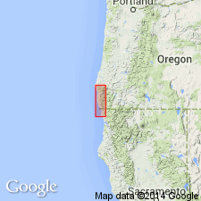
Named for exposures at Cape Sebastian, Curry Co, OR. Type section measured at first headland north of cape (on line between secs.25, 36, T37S R15W), Gold Beach quad. Curry Co, OR. Reference locality in Myers Creek at abandoned sandstone quarry (NW/4 NE/4 secs.7 T38S R14W), Gold Beach 15' quad. Crops out over 30 sq. mi area at and south of Cape Sebastian; possibly present on Edwin Creek near Sixes River. Consists of lower conglomerate part (one-third to one-half of formation) and upper massive sandstone; conglomerate is in lenses (3 in.-to 3 ft. thick) with clasts up to one foot long and local crude graded bedding; sandstone is chiefly moderately well sorted, locally cross stratified, very massive, and fine- to medium-grained, characterized by box-work or honeycomb weathering. Is 800 ft (exposed) thick at type section. Overlies Otter Point Formation with apparent angular unconformity (base is below sea level); gradationally underlies Hunters Cove Formation (new) with top of Cape Sebastian at type section placed at bottom of mudstone bed in 100 ft transition zone with Hunters Cove [placement of boundary in transition zone makes formation assignment, away from type, very difficult; needs more natural boundary]. Is Campanian age (Late Cretaceous) based on occurrence of INOCERAMUS spp. from sandstone at Myers Creek and tip of Cape Sebastian.
Source: GNU records (USGS DDS-6; Menlo GNULEX).
- Usage in publication:
-
- Cape Sebastian Sandstone
- Modifications:
-
- Overview
- AAPG geologic province:
-
- Oregon-Washington Coast Ranges province
Summary:
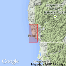
Distribution shown on detailed geologic maps of Gold Beach 15' quad., Curry Co., OR where it is in fault contact with Otter Point Formation.
Source: GNU records (USGS DDS-6; Menlo GNULEX).
- Usage in publication:
-
- Cape Sebastian Sandstone
- Modifications:
-
- Revised
- Areal extent
- AAPG geologic province:
-
- Oregon-Washington Coast Ranges province
Summary:
Revised to stratigraphically exclude lowermost part, rocks called "lower sequence" that are below basal shelly boulder conglomerate ["lower sequence" is beneath angular unconformity first recognized by Hunter and others (1970)]. Is a transgressive sequence that can be roughly divided into four facies (ascending): conglomerate facies (about 25 m thick) of basal conglomerate overlain by trough cross-bedded, plane bedded, and pebbly sandstone (beach to shore face deposits); lower hummocky-bedded sandstone with scattered pebble lenses that decrease upward (storm wave deposits); upper hummocky-bedded fine sandstone and burrowed sandy siltstone (shelf zone deposits); and parallel-laminated and burrowed sand- and siltstone facies (about 50 m thick) of low angle hummocky-bedded to horizontally laminated very fine sandstone alternating with burrowed sandy siltstone (outer shelf deposits). Is probably late Campanian (mid-Campanian to early Maestrichtian) (Late Cretaceous) age based on INOCERAMUS fauna and other bivalves.
Source: GNU records (USGS DDS-6; Menlo GNULEX).
- Usage in publication:
-
- Cape Sebastian Sandstone
- Modifications:
-
- Overview
- AAPG geologic province:
-
- Oregon-Washington Coast Ranges province
Summary:
Overlies Houstenaden Creek Formation (new)(formerly lower sandstone unit of Hunter and others, 1970, and "lower sequence" of Bourgeois, 1980, 1983) with angular unconformity. Houstenaden Creek Formation occurs at tip of first headland north of Cape Sebastian (about 10 m) and on cape itself and to south near Mack Point and Houstenaden Creek. Is (composite) 500 m thick. Represents near-shore to outer-shelf sedimentation. Age is middle or late Campanian (Late Cretaceous).
Source: GNU records (USGS DDS-6; Menlo GNULEX).
For more information, please contact Nancy Stamm, Geologic Names Committee Secretary.
Asterisk (*) indicates published by U.S. Geological Survey authors.
"No current usage" (†) implies that a name has been abandoned or has fallen into disuse. Former usage and, if known, replacement name given in parentheses ( ).
Slash (/) indicates name conflicts with nomenclatural guidelines (CSN, 1933; ACSN, 1961, 1970; NACSN, 1983, 2005, 2021). May be explained within brackets ([ ]).