The National Geologic Map Database is migrating to a new infrastructure. We apologize for any service disruptions during this process.
|
|---|


- Usage in publication:
-
- Canoe Formation
- Modifications:
-
- Areal extent
- Dominant lithology:
-
- Sandstone
- Mudstone
- Tuff
- Lava
- AAPG geologic province:
-
- Permian basin
Summary:
Pg. 12-33, pls., tables, figs., road logs. Canoe Formation of Big Bend Park Group. Base is massive yellow cross-bedded sandstone overlain by tuff, mudstone, tuffaceous sandstone, indurated tuff, and lavas. Thickness as much as 1,170 feet. Basal formation in group. Underlies Chisos Formation; overlies Hannold Hill Formation (new) of Tornillo Group. Age is middle Eocene on basis of fossils (mammalian remains).
Source: US geologic names lexicon (USGS Bull. 1350, p. 117).
- Usage in publication:
-
- Canoe Formation
- Modifications:
-
- Principal reference
- Dominant lithology:
-
- Sandstone
- Mudstone
- Tuff
- Lava
- AAPG geologic province:
-
- Permian basin
Summary:
Pg. 107-112, pls. Canoe Formation of Big Bend Park Group. Formal proposal of name. Includes massive sandstone, conglomeratic sandstone, cross-bedded sandstone, red, purple, gray, and maroon clay and mudstone, gray and gray-white calcareous tuff, indurated vitric tuff, and basaltic lava. Includes Big Yellow Sandstone Member (new) at base. Local lavas within formation are basalt. Individual flows are 17 to 61 feet thick, near type locality where they are deformed by McKinney Hills intrusion, and are 250 and 575 feet, respectively, above base of formation. Underlies Chisos Formation. Overlies Hannold Hills Formation of Tornillo Group. Thickness 1,161 feet at type section [locality]. Age is middle Eocene.
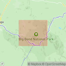
Type section [locality]: northeast of abandoned rock crusher on southern edge of Tornillo Flat, Big Bend National Park, Brewster Co., southwestern TX. Named for Canoe Valley, where its basal unit is folded into a canoe-shaped syncline.
Source: US geologic names lexicon (USGS Bull. 1350, p. 117-118).
For more information, please contact Nancy Stamm, Geologic Names Committee Secretary.
Asterisk (*) indicates published by U.S. Geological Survey authors.
"No current usage" (†) implies that a name has been abandoned or has fallen into disuse. Former usage and, if known, replacement name given in parentheses ( ).
Slash (/) indicates name conflicts with nomenclatural guidelines (CSN, 1933; ACSN, 1961, 1970; NACSN, 1983, 2005, 2021). May be explained within brackets ([ ]).