The National Geologic Map Database is migrating to a new infrastructure. We apologize for any service disruptions during this process.
|
|---|


- Usage in publication:
-
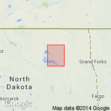
- Cando Formation
- Modifications:
-
- Overview
- AAPG geologic province:
-
- Williston basin
Summary:
Is the basal formation of five formations of the Coleharbor Group. Used in Williston basin of western ND. Described in an unpublished thesis; has been used without formal definition. Includes all glacial deposits below the newly named Camp Grafton Formation of Coleharbor Group. Several glaciations probably represented in Cando. Divided into informal units. Unit E at base: is a shaly till that rests on Cretaceous shale; the till is interbedded with shaly sand and gravel; thickness not stated. Unit D: consists of till and associated stratified glaciofluvial sediment; thickness not stated. Unit C: consists of sand and an overlying till; thickness not stated. Unit B: is mostly silt and sand; thickness not stated. Unit A at top: is a shaly sand and gravel; thickness not stated. Of Pleistocene age. Geologic maps; cross sections.
Source: GNU records (USGS DDS-6; Denver GNULEX).
For more information, please contact Nancy Stamm, Geologic Names Committee Secretary.
Asterisk (*) indicates published by U.S. Geological Survey authors.
"No current usage" (†) implies that a name has been abandoned or has fallen into disuse. Former usage and, if known, replacement name given in parentheses ( ).
Slash (/) indicates name conflicts with nomenclatural guidelines (CSN, 1933; ACSN, 1961, 1970; NACSN, 1983, 2005, 2021). May be explained within brackets ([ ]).