The National Geologic Map Database is migrating to a new infrastructure. We apologize for any service disruptions during this process.
|
|---|


- Usage in publication:
-
- Cameo member
- Modifications:
-
- Named
- Dominant lithology:
-
- Sandstone
- Coal
- Shale
- AAPG geologic province:
-
- Piceance basin
Summary:
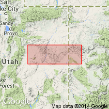
Named as the upper member (of 5) of the Price River Formation in its Neslen facies, the coal-bearing facies, for the town of Cameo, Mesa Co, CO in the Piceance basin. No type locality designated. Lower boundary is with a tongue of Mancos shale. Is younger than the Cozzette member (new) of the Price River. Upper contact indefinite. Its massive white-capped cliff-forming basal sandstone caps Mount Garfield and continues beyond Grand Mesa. The basal sandstone is overlain by the Cameo coal zone [which is implied to be the unit about 250 ft thick that consists of sandstone, sandy shale, carbonaceous shale, and coal]. Above the Cameo zone is the Carbonera coal zone [also part? of the Cameo member]. [Not clearly described.] Of Montana, Late Cretaceous age. [Full areal extent not described.]
Source: GNU records (USGS DDS-6; Denver GNULEX).
For more information, please contact Nancy Stamm, Geologic Names Committee Secretary.
Asterisk (*) indicates published by U.S. Geological Survey authors.
"No current usage" (†) implies that a name has been abandoned or has fallen into disuse. Former usage and, if known, replacement name given in parentheses ( ).
Slash (/) indicates name conflicts with nomenclatural guidelines (CSN, 1933; ACSN, 1961, 1970; NACSN, 1983, 2005, 2021). May be explained within brackets ([ ]).