The National Geologic Map Database is migrating to a new infrastructure. We apologize for any service disruptions during this process.
|
|---|


- Usage in publication:
-
- Caloosahatchie beds
- Modifications:
-
- Original reference
- Dominant lithology:
-
- Marl
- AAPG geologic province:
-
- Florida platform
Summary:
Pg. 161-170. Caloosahatchie beds. The marls of the Caloosahatchie contain a large number of species of which perhaps one-tenth are supposed to be extinct; many of the others are known only from deep water. How many of the so-called extinct ones with turn out to be still living when the deeper waters of the Floridian coast are thoroughly dredged remains to be seen. The age of the Caloosahatchie beds is much the same as others which have been called Pliocene on our eastern coast. The time has not yet arrived, nor is our knowledge of any part of our later Tertiaries sufficient to enable us to decide finally as to their chronologic relation to each other, except in a most tentative way. But without reference to their place in the system, the geologic history of the Caloosahatchie marls is clearly stated in their structure. [On p. 163 Dr. Dall refers to the Caloosahatchie Pliocene.]
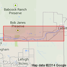
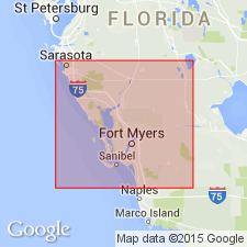
[Named from exposures on Caloosahatchee River, Lee Co., southern FL, especially btw. Labelle and Olga. Extends into northern FL.]
Source: US geologic names lexicon (USGS Bull. 896, p. 320).

- Usage in publication:
-
- Caloosahatchee marl*
- Modifications:
-
- Revised
- AAPG geologic province:
-
- Florida platform
Summary:
Caloosahatchee marl. Redefined so as to include "Nashua" marl, which is so nearly of same age that two names are unnecessary. As here expanded it includes all known marine Pliocene deposits in Florida and a bed containing extinct fresh-water shells, which, according to Dall, lies at top of formation. [Age is early Pliocene.]
Source: US geologic names lexicon (USGS Bull. 896, p. 320).
- Usage in publication:
-
- Caloosahatchee marl
- Modifications:
-
- Age modified
- AAPG geologic province:
-
- Florida platform
Summary:
Pg. 58, 59. Caloosahatchee marl. Prior to 1942, Pliocene series in Florida was composed of Citronelle formation, Tamiami limestone, Buckingham marl, Bone Valley gravel, Alachua formation, Charlton formation, and Caloosahtchee marl. Vernon (1942, Florida Geol. Survey Bull., no. 21) dated part of Citronelle as possibly early Nebraskan and the rest as Pleistocene alluvium. This fieldwork cast some doubt on dating of the "Pliocene" beds in south peninsula. Cooke (1945, Florida Geol. Survey Bull., no. 29) continued to recognize Alachua formation, Bone Valley formation, Buckingham marl, Caloosahatchee formation, Citronelle formation, and Tamiami as Pliocene. Presence of fresh-water mollusks in top of Caloosahatchee (as presently defined by the USGS) casts doubt on its present age assignment. Recognition of upper Miocene beds in the peninsula eliminated all Pliocene beds in southern Florida except Caloosahatchee marl and Bone Valley formation. It is hoped that future fieldwork will definitely place these beds into Miocene or Pleistocene, or definitely prove them to be Pliocene in age.
Source: US geologic names lexicon (USGS Bull. 1200, p. 585-586).

- Usage in publication:
-
- Caloosahatchee marl
- Modifications:
-
- Revised
- Age modified
- Biostratigraphic dating
- AAPG geologic province:
-
- Florida platform
Summary:
Pg. 187-193; Gulf Coast Assoc. Geol. Soc. Trans., v. 8, p. 133-135, 139-144, 1958. Caloosahatchee marl. Subdivided to include (ascending) Fort Denaud, Bee Branch, and Ayers Landing members (all new). Unconformably overlies Tamiami formation; unconformably underlies Fort Thompson formation (Okaldakoochee member, new). Thickness of exposed deposits commonly less than 10 feet, but base of formation visible in only a few places; test holes show thicknesses of 50 to 60 feet or more east of La Belle. Age is Pleistocene (Sangamonian), based on vertebrate fossils.
Source: US geologic names lexicon (USGS Bull. 1200, p. 585-586).
- Usage in publication:
-
- Caloosahatchee marl
- Modifications:
-
- Areal extent
- AAPG geologic province:
-
- Florida platform
Summary:
Pg. 34-37, 41 (fig. 7), 49-64, 76-82, pls. Caloosahatchee marl. Is exposed almost continuously in banks of Caloosahatchee River between Fort Denaud and Fort Thompson. Thickness commonly less than 10 feet. Base exposed only in few places. Exposed beds divided into (ascending) lower marine marl, CYRTOPLEURA COSTATA zone, oyster biostrome, brackish-water marl, Bee Branch member, and upper shell bed. [Report does not use either Fort Denaud member or Ayers Landing marl member.] Unconformably overlies Tamiami formation; unconformably underlies Fort Thompson formation. Age is Pleistocene, primarily on basis of vertebrate fauna and to lesser degree on molluscan fauna and stratigraphic relationships.
Source: US geologic names lexicon (USGS Bull. 1200, p. 585-586).
- Usage in publication:
-
- Caloosahatchee Formation*
- Modifications:
-
- Age modified
- AAPG geologic province:
-
- Florida platform
Summary:
Age changed to late Pliocene and early Pleistocene based on correlation with upper part of the Yorktown Formation in North Carolina.
Source: GNU records (USGS DDS-6; Reston GNULEX).

- Usage in publication:
-
- Caloosahatchee Formation
- Modifications:
-
- Revised
- AAPG geologic province:
-
- Florida platform
Summary:
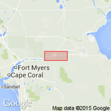
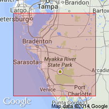
Pg. 598 (fig. 8), 600-601. Caloosahatchee Formation of Port Charlotte Group. Unconsolidated, very fossiliferous, fine calcarenite and interbedded sandy limestones. Exposed thickness 3 m or less; most extensively exposed along Caloosahatchee River, Hendry and Glades Counties, and along Shell Creek, Charlotte County. In subsurface is 1.5 m (at LaBelle) to 50 m (along western margins of Lake Okeechobee) thick. Divided into (descending) Ayers Landing Member, Bee Branch Member, and Fort Denaud Member. Interpreted to represent a transgressive-regressive marine cycle and is considered correlative with the nearshore marine Nashua Formation, also of Port Charlotte. Lies below Bermont Formation of Port Charlotte and above Sarasota Formation of Tamiami Group. Correlates with Waccamaw Formation of the Carolinas. Age is early Pleistocene. Bender (Geochim. Cosmochem. Acta, v. 37, 1973) reported He/U ages of 1.89 to 1.78 Ma for corals collected from type Caloosahatchee. [See also entry under Port Charlotte Group.]
Source: Publication.

- Usage in publication:
-
- Caloosahatchee Formation
- Modifications:
-
- Age modified
- AAPG geologic province:
-
- Florida platform
Summary:
Caloosahatchee Formation is restricted to the late Pliocene (2.5 to 1.8 m.y.) based on LATIRUS recovered from the APAC Mine in Sarasota Co. All marine beds in southern FL that were deposited during the early Pleistocene constitute the Bermont Formation, according to this author.
Source: GNU records (USGS DDS-6; Reston GNULEX).
- Usage in publication:
-
- Caloosahatchee Formation
- Modifications:
-
- Areal extent
- AAPG geologic province:
-
- Florida platform
Summary:
In this report there are four named formations included within Pliocene time in southern FL, including the lower parts of the Caloosahatchee and Anastasia Formations, the Tamiami Formation, and the Peace River Formation of the Hawthorn Group. All are separated from each other and from younger and older units by regional unconformities. The basal part of the Caloosahatchee contains a Blancan vertebrate assemblage at several locations in southern FL, and the formation is considered to have an age range of 2 to 2.5 Ma. The Pliocene-Pleistocene boundary lies on one of the disconformities, but it has not been determined which one.
Source: GNU records (USGS DDS-6; Reston GNULEX).
- Usage in publication:
-
- Caloosahatchee Formation*
- Modifications:
-
- Biostratigraphic dating
- AAPG geologic province:
-
- Florida platform
Summary:
In the Quality Aggregate Phase 6 Pit, APAC Shell Pit, and DeSoto No. 5 Pit, units 10, 8, 7, 6, 3, and 2 of Petuch (1982) are present and are assigned to the Pinecrest Beds of the Tamiami Formation. Younger samples collected at DeSoto, where lowest sample studied has typical Caloosahatchee Formation molluscan fauna (L. Wingard, USGS, 1992, pers. commun.) are tentatively assigned to the Caloosahatchee.
Source: GNU records (USGS DDS-6; Reston GNULEX).
For more information, please contact Nancy Stamm, Geologic Names Committee Secretary.
Asterisk (*) indicates published by U.S. Geological Survey authors.
"No current usage" (†) implies that a name has been abandoned or has fallen into disuse. Former usage and, if known, replacement name given in parentheses ( ).
Slash (/) indicates name conflicts with nomenclatural guidelines (CSN, 1933; ACSN, 1961, 1970; NACSN, 1983, 2005, 2021). May be explained within brackets ([ ]).