

- Usage in publication:
-
- Caldwell Canyon volcanics
- Modifications:
-
- Named
- Dominant lithology:
-
- Breccia
- Tuff
- Latite
- Rhyolite
- AAPG geologic province:
-
- Wind River basin
Summary:
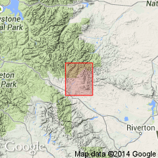
Named for Caldwell Canyon, southwest of Wiggins Peak, Absaroka Range, Fremont Co, WY, in Wind River basin. No type locality designated. Confined to Wiggins Peak and vicinity. Maximum thickness is 300 ft. Consists of glassy laminated, white, red, orange, pink, yellow, gray and black flows. Lower part is soft, buff flow breccias or tuffs. Upper part consists of very fine grained laminated flows of latite or rhyolite. Unconformably overlies Wiggins formation (new). Age is not known. Wiggins beneath was folded and probably eroded before first flows extruded. Assigned to Oligocene?. Geologic map.
Source: GNU records (USGS DDS-6; Denver GNULEX).
- Usage in publication:
-
- Caldwell Canyon Volcanics*
- Modifications:
-
- Geochronologic dating
- Age modified
- AAPG geologic province:
-
- Bighorn basin
Summary:
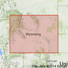
Age modified from Miocene and Pliocene to Miocene on basis of a K-Ar age reported to be of 6.26 Ma on lag gravel at Cougar Pass, sec 14, T45N, R107W, Park Co, WY in the Bighorn basin that lies on top the Caldwell Canyon Volcanics.
Source: GNU records (USGS DDS-6; Denver GNULEX).
For more information, please contact Nancy Stamm, Geologic Names Committee Secretary.
Asterisk (*) indicates published by U.S. Geological Survey authors.
"No current usage" (†) implies that a name has been abandoned or has fallen into disuse. Former usage and, if known, replacement name given in parentheses ( ).
Slash (/) indicates name conflicts with nomenclatural guidelines (CSN, 1933; ACSN, 1961, 1970; NACSN, 1983, 2005, 2021). May be explained within brackets ([ ]).