The National Geologic Map Database is migrating to a new infrastructure. We apologize for any service disruptions during this process.
|
|---|


- Usage in publication:
-
- Cache lake beds*
- Modifications:
-
- Named
- Biostratigraphic dating
- Dominant lithology:
-
- Gravel
- Sand
- Limestone
- AAPG geologic province:
-
- California Coast Ranges province
Summary:
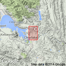
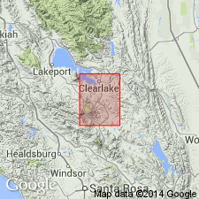
Occurs east of Clear Lake, about the north fork of Cache Creek, Lake Co, CA. Consists of freshwater gravels, sands, and calcareous beds which appear to have great thickness. Contains abundant imperfect plant remains, fresh water shells, and few fragmentary vertebrate remains of a horse (which suggest very late Pliocene age according to Prof. C.O. Marsh).
Source: GNU records (USGS DDS-6; Menlo GNULEX).
- Usage in publication:
-
- Cache formation
- Modifications:
-
- Redescribed
- Age modified
- Biostratigraphic dating
- AAPG geologic province:
-
- California Coast Ranges province
Summary:
Cache Lake beds of Becker (1888) is redescribed as Cache formation because some of the rocks are probably of fluvial origin rather than all of lacustrine origin. Is at least 1700 ft thick between Cache Creek and Franciscan rocks to the west. Is interbedded with lava mapped as basalt of Cache formation on geologic sketch map of Clear Lake area. Overlies with angular discordance Martinez formation. Age is tentatively regarded as early Pleistocene but may be late Pliocene based on fragmentary vertebrate evidence (V.L. VanderHoof).
Source: GNU records (USGS DDS-6; Menlo GNULEX).
- Usage in publication:
-
- Cache formation
- Modifications:
-
- Areal extent
- AAPG geologic province:
-
- California Coast Ranges province
Summary:
Cache formation described in Lower Lake 15' quad where unit swings around southern end of Clear Lake and reappears beneath lavas, north of Seigler Canyon. Consists of freshwater deposits of gravel, silt, and clay except in upper part where tuffaceous deposits, marl, limestone, and diatomite predominate. Is from 300 to 6500 feet thick. Locally overlies serpentine and deposits of Knoxville group.
Source: GNU records (USGS DDS-6; Menlo GNULEX).
- Usage in publication:
-
- Cache Formation*
- Modifications:
-
- Principal reference
- Revised
- Age modified
- Biostratigraphic dating
- Adopted
- AAPG geologic province:
-
- California Coast Ranges province
Summary:
Cache Lake Beds of Becker (1888) and Cache Formation of Anderson (1936) and of Brice (1953) is adopted except for exclusion of beds herein named rhyolitic tuff of Bonanza Springs and Lower Lake Formation (new). Revised Cache Formation is thick sequence of fluvial and partly lacustrine sandstone, conglomerate, and siltstone that is exposed in Clear Lake basin and along North Fork of Cache Creek. Shown on geologic sketch map. Type locality designated along North Fork of Cache Creek between Cache Creek and Benmore Canyon (T14N R6W and T13N R6W) Lower Lake and Bartlett Springs SE 7.5' quads, Lake Co, CA. Measured reference section is in Blackeye Canyon from large bend in canyon westward to mouth, N/2 N/2 sec.13 T14N R7W, Lower Lake 7.5' quad. Maximum thickness is 2000 m. Unconformably overlies serpentinite and Knoxville Formation, Upper Jurassic and Cretaceous rocks of Franciscan assemblage, other Cretaceous rocks, Paleocene Martinez Formation, and is in fault contact with Great Valley sequence. Unconformably underlies Lower Lake Formation and units of Clear Lake volcanic field. Age is Pliocene and early Pleistocene based on fossils (C.A. Repenning, written commun.) and (Taylor, 1966).
Source: GNU records (USGS DDS-6; Menlo GNULEX).
For more information, please contact Nancy Stamm, Geologic Names Committee Secretary.
Asterisk (*) indicates published by U.S. Geological Survey authors.
"No current usage" (†) implies that a name has been abandoned or has fallen into disuse. Former usage and, if known, replacement name given in parentheses ( ).
Slash (/) indicates name conflicts with nomenclatural guidelines (CSN, 1933; ACSN, 1961, 1970; NACSN, 1983, 2005, 2021). May be explained within brackets ([ ]).