The National Geologic Map Database is migrating to a new infrastructure. We apologize for any service disruptions during this process.
|
|---|


- Usage in publication:
-
- Cabots Head beds
- Modifications:
-
- Named
- Dominant lithology:
-
- Shale
- Limestone
- Sandstone
- AAPG geologic province:
-
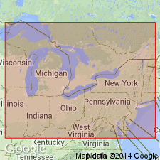
- Appalachian basin
Summary:
Named for exposures at Cabots Head, Manitoulin Islands, Ontario, Canada. Consists of green, calcareous to argillaceous shales and thin-bedded limestones underlain by 100 to 150 feet of red shale and some sandstone. Thickness at Niagara is about 125 feet. Believed to be westward extension of Medina sedimentation. Overlies Koppel dolomite. Age is Early Silurian.
Source: GNU records (USGS DDS-6; Reston GNULEX).
- Usage in publication:
-
- Cabot Head shale member*
- Modifications:
-
- Areal extent
- AAPG geologic province:
-
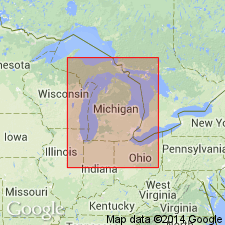
- Michigan basin
Summary:
Cabot Head shale member of Cataract formation extended into lower Michigan peninsula. Remains Cabot Head shale in southwestern Ontario.
Source: GNU records (USGS DDS-6; Reston GNULEX).
For more information, please contact Nancy Stamm, Geologic Names Committee Secretary.
Asterisk (*) indicates published by U.S. Geological Survey authors.
"No current usage" (†) implies that a name has been abandoned or has fallen into disuse. Former usage and, if known, replacement name given in parentheses ( ).
Slash (/) indicates name conflicts with nomenclatural guidelines (CSN, 1933; ACSN, 1961, 1970; NACSN, 1983, 2005, 2021). May be explained within brackets ([ ]).