The National Geologic Map Database is migrating to a new infrastructure. We apologize for any service disruptions during this process.
|
|---|


- Usage in publication:
-
- Butterfield limestone member
- Modifications:
-
- Original reference
- Dominant lithology:
-
- Limestone
- AAPG geologic province:
-
- Great Basin province
Summary:
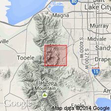
Pg. 37, map, section. Butterfield limestone member of Bingham quartzite. Present in Bingham district, northern Utah. Chiefly blue and dark-blue limestones, usually pure carbonate of lime, but many siliceous layers are present, and occasionally beds of sandy limestone occur, also small chert nodules and round balls; the chert is black, alternating, in the larger nodules, with concentric, dark-gray bands. Thickness 200 feet. Lies much lower than Jordan limestone member (new). [Map shows it exposed in Butterfield Canyon, southeast corner of sheet.] Age is Pennsylvanian
Source: US geologic names lexicon (USGS Bull. 896, p. 305).
- Usage in publication:
-
- Butterfield Limestone Member†
- Modifications:
-
- Abandoned
- AAPG geologic province:
-
- Great Basin province
Summary:
Pg. A5-A8. †Butterfield Limestone Member of †Bingham Quartzite. The Bingham Quartzite of Keith (1905, USGS Prof. Paper 38, p. 33-35, pls. 1, 2) is here considered abandoned. It has not been used for many years; workers have applied name Oquirrh Formation (as defined by Gilluly, 1932) to these rocks. Keith (1905) also designated several prominent limestone lentils and members in the Bingham (ascending): Tilden (Petro) and Phoenix Limestone Lentils, and Butterfield, Lenox, Jordan, Commercial, Highland Boy, and Yampa Limestone Members. These names and others used in the mines to designate important ore-forming horizons are abandoned as formally named units and considered local informal marker beds. However, owing to confusion arising from the fact that the Butterfield Limestone Member of Keith (1905) occurs in the "White Pine" Formation of Welsh and James (1961) but not in the Butterfield Formation, the combined unit is here included in the Butterfield Peaks Formation (new) of the Oquirrh Group (fig. 5, section 7).
Source: Publication; Changes in stratigraphic nomenclature, 1970 (USGS Bull. 1354-A, p. A4-A5).
For more information, please contact Nancy Stamm, Geologic Names Committee Secretary.
Asterisk (*) indicates published by U.S. Geological Survey authors.
"No current usage" (†) implies that a name has been abandoned or has fallen into disuse. Former usage and, if known, replacement name given in parentheses ( ).
Slash (/) indicates name conflicts with nomenclatural guidelines (CSN, 1933; ACSN, 1961, 1970; NACSN, 1983, 2005, 2021). May be explained within brackets ([ ]).