

- Usage in publication:
-
- Bullwhacker member*
- Modifications:
-
- Original reference
- Biostratigraphic dating
- Dominant lithology:
-
- Limestone
- AAPG geologic province:
-
- Great Basin province
Summary:
Pg. 20, 21, 22, pls. 1, 2. Bullwhacker member of Windfall formation (new). Composed of a rather uniform sequence of thin-bedded platy or shaly limestone, some of which is slightly silty; on fresh fracture, color ranges from medium light- to medium dark-gray. Shaly or sandy partings and thin interbeds weather to buff or pinkish, and whole member has a collective yellowish-tan color that is distinctive. Limestone beds are from 0.25 to 1 inch thick and are fine-grained to subporcellaneous in texture. Commonly 400 feet thick throughout area. At Eureka it appears to be conformable with both Catlin member (new) of Windfall formation below and Goodwin limestone of Pogonip group above. Is upper member of Windfall. Fossils [listed] identified by A.R. Palmer; dominated by trilobites ELKIA NASUTA (Walcott) (=PARABRISCOIA spp. of Kobayashi) and EUREKIA GRANULOSA Walcott. Age is [possibly considered late Late Cambrian], based on fossils; correlates with slightly younger horizons in same lithologic units as Catlin member.
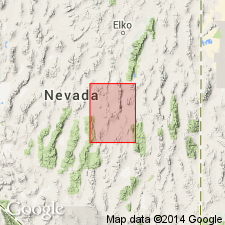
Named from exposures in vicinity of Bullwhacker Mine, [along bdry. btw. secs. 10 and 15 (unsurveyed), T. 19 N., R. 53 E., approx. Lat. 39 deg. 31 min. 28 sec. N., Long. 115 deg. 59 min. 36 sec. W., southwestern corner Eureka 15-min quadrangle (1953 ed.)], Eureka district, Eureka Co., central NV.
[Additional locality information from USGS historical topographic map collection TopoView, accessed Memorial Day 2018.]
Source: Publication; US geologic names lexicon (USGS Bull. 1200, p. 532).
For more information, please contact Nancy Stamm, Geologic Names Committee Secretary.
Asterisk (*) indicates published by U.S. Geological Survey authors.
"No current usage" (†) implies that a name has been abandoned or has fallen into disuse. Former usage and, if known, replacement name given in parentheses ( ).
Slash (/) indicates name conflicts with nomenclatural guidelines (CSN, 1933; ACSN, 1961, 1970; NACSN, 1983, 2005, 2021). May be explained within brackets ([ ]).