The National Geologic Map Database is migrating to a new infrastructure. We apologize for any service disruptions during this process.
|
|---|


- Usage in publication:
-
- Bulldog Hollow Member*
- Modifications:
-
- Original reference
- Biostratigraphic dating
- Geochronologic dating
- Dominant lithology:
-
- Mudstone
- Sandstone
- AAPG geologic province:
-
- Green River basin
Summary:
Pg. 35-37, 41, 46-47. Bulldog Hollow Member of Fowkes Formation. Pale- to dark-green, blue-green, and white tuffaceous and ashy mudstone, and green to buff and brown tuffaceous calcareous sandstone. Has a few lenses of light-gray, calcareous conglomerate. Thickness 239 feet at type section, 200 feet north of Sage, and may be as much as several thousand feet south of Sage quadranlge. Overlies Sillem Member (new) of Fowkes Formation; underlies Gooseberry Member (new) of Wasatch Formation. Fossils (gastropods, leaves) indicate middle or late Eocene age. Sample collected from the Bulldog Hollow Member yielded a K-Ar age (hornblende) of 47.7 +/-1.5 Ma (middle Eocene). Age is Eocene, probably middle Eocene.
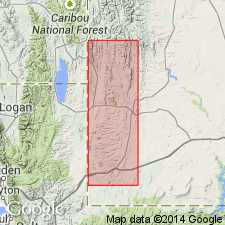
Type section: north of Sage, in W/2 sec. 33, T. 22 N., R. 119 W., [Sage 7.5-min quadrangle], Lincoln Co., southwestern WY. Named from extensive exposures along Bulldog Hollow, south of Sage, [Sage 7.5-min quadrangle], Lincoln Co., southwestern WY.
Source: Publication; US geologic names lexicon (USGS Bull. 1520, p. 43).
- Usage in publication:
-
- Bulldog Hollow Member*
- Modifications:
-
- Overview
- Dominant lithology:
-
- Tuff
- Sandstone
- Siltstone
- Mudstone
- Claystone
- Conglomerate
- AAPG geologic province:
-
- Green River basin
Summary:
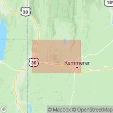
Is the middle of 3 members of the Fowkes Formation. Present in west side of mapped area, north and south of Twin Creek, Lincoln County, Wyoming, Greater Green River basin. Mapped as far north as Antelope Creek, in sec. 10, T. 22 N., R. 119 W. Described as a gray, green to white tuff, and moderately to dominantly tuffaceous ashy rhyolitic sandstone, siltstone, mudstone, and claystone, containing thin lenses of very light-gray conglomerate with sandy limestone matrix or opaline cement. Biotite and magnetite abundant, particularly in the green, fine- to medium-grained, tuffaceous sandstone beds. Ranges from 200 feet thick southward to several thousand feet thick. Overlies Sillem Member of Fowkes. Underlies Gooseberry Member of Fowkes. Has freshwater mollusks of middle or late Eocene age, and a tuff of middle Eocene age. Vertebrate fossils found to north of area. Report includes geologic map, cross sections.
Source: Modified from GNU records (USGS DDS-6; Denver GNULEX).
For more information, please contact Nancy Stamm, Geologic Names Committee Secretary.
Asterisk (*) indicates published by U.S. Geological Survey authors.
"No current usage" (†) implies that a name has been abandoned or has fallen into disuse. Former usage and, if known, replacement name given in parentheses ( ).
Slash (/) indicates name conflicts with nomenclatural guidelines (CSN, 1933; ACSN, 1961, 1970; NACSN, 1983, 2005, 2021). May be explained within brackets ([ ]).