The National Geologic Map Database is migrating to a new infrastructure. We apologize for any service disruptions during this process.
|
|---|


- Usage in publication:
-
- Bull Hill gneiss
- Modifications:
-
- Original reference
- Dominant lithology:
-
- Gneiss
- AAPG geologic province:
-
- New England province
Summary:
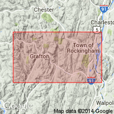
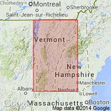
Pg. 221. Bull Hill gneiss. New name, is necessary because of rather wide distribution of the gneiss and its characteristic structure. Type locality is on Bull Hill, east to northeast of village of Grafton and north of village of Cambridgeport, Windham County, southeastern Vermont. [In Saxtons River quadrangle.] The hill reaches altitude of 1,580 feet and is practically all gneiss. Also well exposed in northeast part of Grafton Township. The gneiss is profoundly porphyritic; is cut by pegmatite veins. Also occurs near southeast corner of Chester. Structure and texture are markedly different from that of Reading gneiss. It appears to be an orthognelss. Age is unknown.
Source: US geologic names lexicon (USGS Bull. 896, p. 291).
- Usage in publication:
-
- Bull Hill gneiss
- Modifications:
-
- Revised
- AAPG geologic province:
-
- New England province
Summary:
Pg. 316-347. Bull Hill gneiss. Acid intrusive, embraces only those gneisses that are pronouncedly porphyritic.
Source: US geologic names lexicon (USGS Bull. 896, p. 291).
- Usage in publication:
-
- Bull Hill Gneiss Member
- Modifications:
-
- Geochronologic dating
- AAPG geologic province:
-
- New England province
Summary:
Two samples of the Bull Hill Gneiss Member of the Cavendish Formation (of Doll and others, 1961) from the Chester dome and one from the southeastern part of the Green Mountain massif give zircon concordia upper intercept ages of 945+/-7, 955+/-5, and 965+/-4 Ma. Similar in age to the Stamford Granite Gneiss of the southern Green Mountain massif. Indicates occurrence of widespread igneous event of this age in the Grenville Province. Unit is older than the Late Proterozoic to Cambrian age of the basal cover rocks and cannot be conformably interstratified with them as suggested by Doll and others (1961). [Author does not revise the nomenclature in this report.]
Source: GNU records (USGS DDS-6; Reston GNULEX).
- Usage in publication:
-
- Bull Hill Gneiss*
- Modifications:
-
- Revised
- Areal extent
- Geochronologic dating
- Dominant lithology:
-
- Gneiss
- AAPG geologic province:
-
- New England province
Summary:
Cardinal Brook Intrusive Suite is here named in the cores of the Chester-Athens dome and Rayponda-Sadawga dome in the eastern and southern Green Mountains, VT, and the northern part of the Berkshire massif, MA. Includes the Stamford Granite of Hitchcock (1861), the Somerset Reservoir Granite (new name), the Harriman Reservoir Granite (new name), and the Bull Hill Gneiss of Richardson (1929-30). Because of uncertainty regarding the geologic position of the Bull Hill, it is restricted to the Chester and Athens domes and the original definition of Richardson is retained. Rocks mapped as Bull Hill in the Jamaica area are assigned to the Somerset Reservoir Granite and those in the Rayponda-Sadawga dome are assigned to the Harriman Reservoir Granite. Structural position is unclear. U-Pb zircon age is Middle Proterozoic (960-950 Ma). . [GNU Staff note--This report mistakenly uses the phrasing "Bull Hill Gneiss of Richardson (1929-30)" which would normally imply that the unit has not been adopted for use by the U.S. Geological Survey (USGS) because of inadequate definition by Richardson or successive workers in the area. However, in this report, the phrasing simply means that Richardson's definition and use are preferred over the usage on the VT State Geologic Map of Doll and others (1961) and that the unit meets the requirements for formal usage by the USGS.]
Source: GNU records (USGS DDS-6; Reston GNULEX).
- Usage in publication:
-
- Bull Hill Gneiss*
- Modifications:
-
- Overview
- AAPG geologic province:
-
- New England province
Summary:
Bull Hill Gneiss of Cardinal Hill Intrusive Suite used in this report. Occurs in the Kenny Pond slice (a fault sliver), at the southern margin of the Athens dome.
Source: GNU records (USGS DDS-6; Reston GNULEX).
For more information, please contact Nancy Stamm, Geologic Names Committee Secretary.
Asterisk (*) indicates published by U.S. Geological Survey authors.
"No current usage" (†) implies that a name has been abandoned or has fallen into disuse. Former usage and, if known, replacement name given in parentheses ( ).
Slash (/) indicates name conflicts with nomenclatural guidelines (CSN, 1933; ACSN, 1961, 1970; NACSN, 1983, 2005, 2021). May be explained within brackets ([ ]).