

- Usage in publication:
-
- Bull Creek formation
- Modifications:
-
- First used
- AAPG geologic province:
-
- Cascades province
Summary:
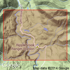
Bull Creek Formation mentioned in discussion of trip along the Clackamas River. Present at Ripple Creek Junction. Unusual because of occurrence in region of completely igneous rock. Beds tipped at angle of 45 degrees. [Age is not stated.]
Source: Modified from GNU records (USGS DDS-6; Menlo GNULEX).
- Usage in publication:
-
- Bull Creek Beds*
- Modifications:
-
- Revised
- AAPG geologic province:
-
- Cascades province
Summary:
In this report, Bull Creek Beds of Barnes and Butler (1930, unpub. thesis) assigned to Little Butte volcanic series [informal]. [Proposal conflicts with nomenclature guidelines. Term "Series" is applied formally only to chronostratigraphic units (see ACSN, 1961, 1970).] Steep dips and variable strikes are result of slumping which is widespread in upper Clackamas River Valley where Columbia River Basalt overlies soft tuffs. Bull Creek Beds are composed of volcanic conglomerate and water-laid tuff in upper Clackamas River Valley south and west of Oak Grove Ranger Station. Separated from overlying Eagle Creek Formation of Little Butte volcanic series, because unit dips steeply in contrast to almost flatlying strata of Eagle Creek Formation. Age of Little Butte volcanic series ranges from early or middle Oligocene to early Miocene based on fossil plants.
Source: Modified from GNU records (USGS DDS-6; Menlo GNULEX).
- Usage in publication:
-
- Bull Creek, beds of
- Modifications:
-
- Revised
- AAPG geologic province:
-
- Cascades province
Summary:
Beds of Bull Creek "were named informally by Barnes and Butler (1936) for strata exposed near Ripplebrook in the Fish Creek Mountain quadrangle." Consist of dark-brown to gray-colored interstratified thick laharic deposits, thinner fluvial volcaniclastic conglomerates and sandstones and minor andesitic and basaltic lava flows. Maximum thickness is about 375 m. Beds intertongue with andesite of Nohorn Creek and Grande Ronde Basalt of Columbia River Basalt Group. Age is about 20 to 14 Ma. Pollen sequence of Miocene age found by Wolfe (1962) at number of sites within beds. Beds are shown on map and in cross section of upper Clackamas area as part of Western Cascades Group. Strata are lithologically similar and probably equivalent to Eagle Creek Formation of Columbia River Gorge (citing Wolfe, 1954; Hammond, 1980).
Source: GNU records (USGS DDS-6; Menlo GNULEX).
For more information, please contact Nancy Stamm, Geologic Names Committee Secretary.
Asterisk (*) indicates published by U.S. Geological Survey authors.
"No current usage" (†) implies that a name has been abandoned or has fallen into disuse. Former usage and, if known, replacement name given in parentheses ( ).
Slash (/) indicates name conflicts with nomenclatural guidelines (CSN, 1933; ACSN, 1961, 1970; NACSN, 1983, 2005, 2021). May be explained within brackets ([ ]).