The National Geologic Map Database is migrating to a new infrastructure. We apologize for any service disruptions during this process.
|
|---|


- Usage in publication:
-
- Bug Scuffle limestone member
- Modifications:
-
- Areal extent
- Dominant lithology:
-
- Limestone
- AAPG geologic province:
-
- Orogrande basin
Summary:
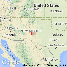
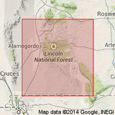
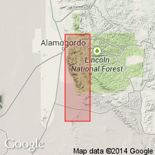
Pg. 93. Bug Scuffle limestone member of Gobbler formation of Magdalena group. Appears only on composite columnar section, Sacramento Mountains, Otero County, southeastern New Mexico. Consists of massive gray cherty limestone which grades laterally into sandstone and shale. [Age is Early(?) to Late Pennsylvanian (Morrowan? to Missourian).]
[Notable exposures in Sacramento Mountains, Otero Co., southeastern NM.]
Source: US geologic names lexicon (USGS Bull. 1200, p. 525).
- Usage in publication:
-
- Bug Scuffle limestone member
- Modifications:
-
- Principal reference
- Dominant lithology:
-
- Limestone
- AAPG geologic province:
-
- Orogrande basin
Summary:
Bug Scuffle limestone member, in upper part of Gobbler formation of Magdalena group. Present in the Sacramento Mountains. Consists of massive gray limestone. Thickness not given; shown as about 1,000 feet thick on a cross section. Overlies and underlies unnamed parts of the Gobbler. May underlie Beeman formation of Magdalena group. Age is Middle and Late Pennsylvanian, mostly Desmoinesian, some is Missourian at top. Report includes cross sections, columnar section, generalized geologic map.
Type section: on Long Ridge, in sec. 15, T. 17 S., R. 10 E., Otero Co., NM. Named from Bug Scuffle Canyon, Bug Scuffle Hill, and Bug Scuffle quadrangle.
Source: Modified from GNU records (USGS DDS-6; Denver GNULEX).
- Usage in publication:
-
- Bug Scuffle limestone member
- Modifications:
-
- Overview
- AAPG geologic province:
-
- Orogrande basin
Summary:
Section measured in the Mule Canyon and Long Ridge area, NW1/4 NW1/4 sec 14, and NE1/4 NW1/4 and NW1/4 NE1/4 sec 15, T17S, R10E, Otero Co, NM, Orogrande basin, designated the type section of the Gobbler formation. The Bug Scuffle stated to be the limestone facies 700 to 1,000 ft above base of Gobbler, but member not specifically identified in measured section. Name applied to the calcarenite and calcilutite, commonly cherty facies of the Gobbler. Forms conspicuous sheer cliffs 500 to 700 ft high almost exclusively of limestone. Chert nodules occur in many layers. Fossils--brachiopods, crinoids, bryozoans, corals, calcareous algae, Foraminifera--occur throughout. Can be as much as 1,000 ft thick. Is contemporaneous with the unnamed detrital facies of the Gobbler. Overlies an unnamed portion of the Gobbler--usually the unnamed lower 200 to 500 ft of the Gobbler. Underlies Beeman formation. Assigned to the Des Moinesian. Geologic map, columnar sections, cross sections.
Source: GNU records (USGS DDS-6; Denver GNULEX).
For more information, please contact Nancy Stamm, Geologic Names Committee Secretary.
Asterisk (*) indicates published by U.S. Geological Survey authors.
"No current usage" (†) implies that a name has been abandoned or has fallen into disuse. Former usage and, if known, replacement name given in parentheses ( ).
Slash (/) indicates name conflicts with nomenclatural guidelines (CSN, 1933; ACSN, 1961, 1970; NACSN, 1983, 2005, 2021). May be explained within brackets ([ ]).