

- Usage in publication:
-
- Buford Canyon Formation*
- Modifications:
-
- Original reference
- Dominant lithology:
-
- Conglomerate
- Volcanics
- AAPG geologic province:
-
- Basin-and-Range province
Summary:
Pg. 9 (table), 41-44, pl. 1. Buford Canyon Formation. A sequence of sedimentary and volcanic rocks. On basis of lithology divided into lower conglomerate member and upper volcanic member. Conglomerate member is at least 700 feet thick in Buford Canyon and 200 to 600 feet thick in Klondyke Wash. Volcanic member at least 1,500 feet thick in Buford Canyon and Klondyke Wash. Top of volcanic member not exposed, and member everywhere overlain with pronounced angular unconformity by older alluvium. Formation trends northwest, and beds dip from 30 to 65 deg. SW in region northeast of Silver Coin mine to 40 to 80 deg. SW in Buford Canyon. Age not known with even accuracy of a geologic era. Formation rests on early Precambrian Pinal Schist, is faulted against Horse Mountain Volcanics (new) at one place, and is overlain by older alluvium of Pliocene or Pleistocene age. Appears to be unfossiliferous. Presumably of Mesozoic and Cenozoic age, since no similar rocks are found in Paleozoic sequence anywhere in southeastern Arizona.
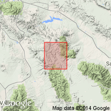
Named from exposures in Buford Canyon in [secs. 12, 14], T. 7 S., R. 20 E., Klondyke 15-min quadrangle, [Graham Co.], southeastern AZ. Crops out in three places in northeast part of T. 7 S., R. 20 E. Occupies an area of about a sq mi, or about 4 percent of the quadrangle.
Source: US geologic names lexicon (USGS Bull. 1350, p. 100).
For more information, please contact Nancy Stamm, Geologic Names Committee Secretary.
Asterisk (*) indicates published by U.S. Geological Survey authors.
"No current usage" (†) implies that a name has been abandoned or has fallen into disuse. Former usage and, if known, replacement name given in parentheses ( ).
Slash (/) indicates name conflicts with nomenclatural guidelines (CSN, 1933; ACSN, 1961, 1970; NACSN, 1983, 2005, 2021). May be explained within brackets ([ ]).