The National Geologic Map Database is migrating to a new infrastructure. We apologize for any service disruptions during this process.
|
|---|


- Usage in publication:
-
- Buffalo stage*
- Modifications:
-
- Named
- Dominant lithology:
-
- Till
- AAPG geologic province:
-
- Yellowstone province
- Snake River basin
Summary:
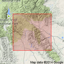
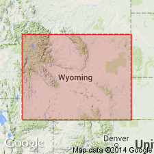
Is oldest of three glacial stages (Buffalo, Bull Lake, and Pinedale stages) recognized based on study of deposits of more than forty-five Pleistocene glaciers distributed over large part of western WY. Deposits of the Buffalo stage (Buffalo drift) named from their typical occurrence along Buffalo Fork of Snake River, Teton Co., WY (Yellowstone province). Type locality not designated. Occurs as "remnants on flat-topped divides or hills, and on spurs along valley slopes." Full extent of the Buffalo ice is indeterminable, however it covered a much larger area than the glaciers of the Bull Lake and Pinedale stages. Glaciers of the Bull Lake and Pinedale stages were valley glaciers, while the Buffalo stage produced a large piedmont glacier that "spread westward from the north end of the Teton Range, and Yellowstone Park appears to have been almost entirely buried under a mass of ice." Sketch map (fig 46) shows areal distribution of Buffalo drift on northwest side of Teton Range, WY and ID. Striated boulders of Buffalo age occur southeast of Ashton, Bonneville Co., ID (Snake River basin). The nature of the deposits suggests that "the period between the Buffalo and the Bull Lake glacial stages was several times as long as the next succeeding inter-glacial interval, and many times longer than the post-glacial epoch." Summary scheme (table II, p. 310) of glacial stages and erosion cycles, shows Buffalo stage occurred between Black Rock (older) and Circle (younger) erosion cycles.
Source: GNU records (USGS DDS-6; Denver GNULEX).
- Usage in publication:
-
- Buffalo Till
- Modifications:
-
- Not used
Summary:
Three glaciations are represented in the Wind River Mountains of WY by deposits that were assigned originally to the Buffalo Till. Deposits in the Wind River Mountains formerly assigned to the Buffalo lie above or beyond the outer limits of the younger --Bull Lake and Pinedale --tills. Some deposits assigned to the Buffalo occur as small patches, some are zones of erratic boulders. Most are sheet-like deposits that cap interstream divides, 200 to 1,000+ ft above the trunk streams. No correlation attempted between tills of Wind River Range with deposits on the North Fork of the Snake River. The 3 tills are named (ascending): Cedar Ridge Till, Sacagawea Ridge Till, and Dinwoody Lake Till. All are of pre-Wisconsin, Pleistocene age.
Source: GNU records (USGS DDS-6; Denver GNULEX).
- Usage in publication:
-
- Buffalo till*, glaciation*†
- Modifications:
-
- Abandoned
Summary:
Many deposits in the Green River drainage correlated with the Buffalo "till or glaciation" are Tertiary conglomerate. Reexamination of deposits assigned to Buffalo along Buffalo Fork of the Snake River indicates these deposits are Pinedale or Bull Lake in age. Term Buffalo abandoned.
Source: GNU records (USGS DDS-6; Denver GNULEX).
For more information, please contact Nancy Stamm, Geologic Names Committee Secretary.
Asterisk (*) indicates published by U.S. Geological Survey authors.
"No current usage" (†) implies that a name has been abandoned or has fallen into disuse. Former usage and, if known, replacement name given in parentheses ( ).
Slash (/) indicates name conflicts with nomenclatural guidelines (CSN, 1933; ACSN, 1961, 1970; NACSN, 1983, 2005, 2021). May be explained within brackets ([ ]).