

- Usage in publication:
-
- Buckrange sand lentil*
- Modifications:
-
- Original reference
- Dominant lithology:
-
- Sand
- AAPG geologic province:
-
- Ouachita folded belt
Summary:
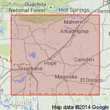
Buckrange sand lentil of Ozan formation. Sandy marl or marly sand, 3 to 15 feet thick, containing as much as 50 percent of coarse glauconite grains. Is basal part of Ozan formation in Sevier, Howard, and Hempstead Counties, southwestern Arkansas. Grades into overlying marl of Ozan formation. Age is Late Cretaceous (Gulf).
Outcrops short distance north of village of Buckrange, Howard Co., southwestern AR, also 1 mi north of village, on road to Nashville. Thins to east.
[See also Dane, Arkansas Geol. Survey Bull., no. 1, 1929, p. 59.]
Source: US geologic names lexicon (USGS Bull. 896, p. 285).
- Usage in publication:
-
- Buckrange formation
- Modifications:
-
- Areal extent
- AAPG geologic province:
-
- Arkla basin
- East Texas basin
Summary:
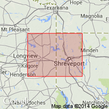
Underlies unnamed unit below Ozan formation. Overlies Tokio formation. Is extended in subsurface into eastern Harrison Co, TX and eastern Caddo Parish, LA in the East Texas and Arkla basins, respectively. Thickness in Longwood field is about 107 ft. Depth to top is 1,857 ft (elevation -1,543 ft). [The unit described here is probably equivalent to Blossom Sand.]
Source: GNU records (USGS DDS-6; Denver GNULEX).
For more information, please contact Nancy Stamm, Geologic Names Committee Secretary.
Asterisk (*) indicates published by U.S. Geological Survey authors.
"No current usage" (†) implies that a name has been abandoned or has fallen into disuse. Former usage and, if known, replacement name given in parentheses ( ).
Slash (/) indicates name conflicts with nomenclatural guidelines (CSN, 1933; ACSN, 1961, 1970; NACSN, 1983, 2005, 2021). May be explained within brackets ([ ]).