The National Geologic Map Database is migrating to a new infrastructure. We apologize for any service disruptions during this process.
|
|---|


- Usage in publication:
-
- Browns Pond Formation
- Modifications:
-
- Principal reference
- Dominant lithology:
-
- Limestone
- Sandstone
- Graywacke
- AAPG geologic province:
-
- New England province
Summary:
Pg. 188-193 (figs. 1, 2), 195-196, 204. Browns Pond Formation. Lenses of limestone, limestone conglomerate, limestone breccia, quartz wacke, dolomitic calc-arenite, and quartz arenite, within a predominantly black slate matrix. Thickness 25 to 130 m; typically 80 m. Includes, descending: Black Patch (Eddy Hill) Grit [Dale (1899), Ruedemann (1914)], a distinctive gray to black silty wacke containing well-rounded quartz grains and dark slate rip-up clasts; and Mudd Pond Quartzite, a clean medium- to coarse-grained thick-bedded quartzite. [On p. 204, the Black Patch (Eddy Hill) and Mudd Pond are loosely referred to as members; the USGS considers these informal unranked units.] Overlies Truthville Slate Formation, contact is sharp and marked by distinct color change from gray-green to black; underlies Mettawee Slate Formation (sensu strictu). Age is considered Early Cambrian; fossils (late Early Cambrian ELLIPTOCEPHALA ASAPHOIDES fauna) identified from top of formation, citing Theokritoff (GSA Bull., v. 75, 1964).
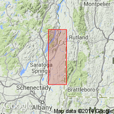
Type locality: northwest of Granville, along Holcombville Road near Browns Pond, at the Granville-Thorn Hill 7.5-min quadrangle boundary, Washington Co., eastern NY. Name credited to L.D. Jacobi [L.L. Delano], 1977, SUNY-Albany MS thesis.
[T.N. Dale IN USGS 19th Ann. Rpt., pt. 3 econ. geol., p. 153-307, 1899; Rudolf Ruedemann IN Cushing and Ruedemann, Geol. Saratoga Springs and vicinity, New York State Mus. Bull., no. 169, p. 66-99, 1914.]
Source: Publication; US geologic names lexicon (USGS Bull. 1565, p. 45-46).
- Usage in publication:
-
- Browns Pond Formation
- Modifications:
-
- Mapped
- AAPG geologic province:
-
- New England province
Summary:
Geol. map. Browns Pond Formation of Rowley and others (1979). Gray to black slates containing, from top to lower part, coarse limestone breccia, bedded calcarenites (rare), gray-black quartz sand-bearing wacke (Black Patch Grit Member), and coarse, thick-bedded orthoquartzite (Mudd Pond Member). ELLIPTOCEPHALA ASAPHOIDES fauna in limestones, which are ubiquitous in the upper part of the unit. Age is Early Cambrian (Taconian).
[Mapped along eastern edge of map, east of Giddings Brook gravity slide fault, from Granville to Fair Haven, Granville and Thorn Hill 7.5-min quadrangles, Washington Co., eastern NY.]
Source: Publication.

- Usage in publication:
-
- Browns Pond Formation*
- Modifications:
-
- Areal extent
- AAPG geologic province:
-
- New England province
Summary:
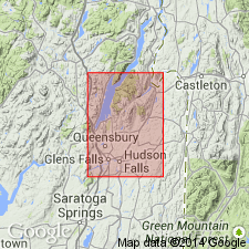
Used as Browns Pond Formation of Cambrian age. Occurs in Taconic allochthon sequence in Glens Falls quad. Overlies Nassau Formation; underlies Middle Granville Formation of Fisher (1984).
Source: GNU records (USGS DDS-6; Reston GNULEX).
- Usage in publication:
-
- Browns Pond Formation of Rowley and others (1979)
- Modifications:
-
- Mapped
- AAPG geologic province:
-
- New England province
Summary:
Browns Pond Formation of Rowley and others (1979). Gray to black slate, punky weathering calcitic wacke and mudstone, thin limestone breccia in part equivalent to West Castleton Formation. Locally purple and green slate above black slate of the Browns Pond is interpreted as a lens of Mettawee slate facies in the Bull Formation. Age is Early Cambrian.
Shown only in the Granville area, Washington Co., NY.
Source: Publication.
For more information, please contact Nancy Stamm, Geologic Names Committee Secretary.
Asterisk (*) indicates published by U.S. Geological Survey authors.
"No current usage" (†) implies that a name has been abandoned or has fallen into disuse. Former usage and, if known, replacement name given in parentheses ( ).
Slash (/) indicates name conflicts with nomenclatural guidelines (CSN, 1933; ACSN, 1961, 1970; NACSN, 1983, 2005, 2021). May be explained within brackets ([ ]).