The National Geologic Map Database is migrating to a new infrastructure. We apologize for any service disruptions during this process.
|
|---|


- Usage in publication:
-
- Brook Ranch member
- Modifications:
-
- Original reference
- Dominant lithology:
-
- Limestone
- AAPG geologic province:
-
- Llano uplift
Summary:
Pg. 142, 143 (table), 144-145; 1947, Jour. Geol., v. 55, no. 3, pt. 2, p. 196 (table 2), 197 (fig. 2), 198. Brook Ranch member of Big Saline formation. Present in central Texas. Typically very hard subcrystalline dark-gray, nearly black cherty limestone. Total thickness 15 to 25 feet. Overlies Gibbons conglomerate member, west side of Cavern Ridge; underlies Lemons Bluff member. Age is Pennsylvanian.
Source: US geologic names lexicon (USGS Bull. 1200, p. 492).
- Usage in publication:
-
- Brook Ranch lentil
- Brook Ranch member
- Modifications:
-
- [Principal reference]
- Revised
- AAPG geologic province:
-
- Permian basin
- Llano uplift
Summary:
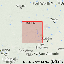
Pg. 64. Brook Ranch lentil and Brook Ranch member of Big Saline formation. Brook Ranch lentil makes up basal layers of Big Saline in Kimble, Mason, and McCulloch Counties, central Texas. Occurs between Gibbons conglomerate lentil and Lemons Bluff member, where it is present, and otherwise between Gibbons conglomerate or older rocks and Soldiers Hole limestone beds. Brook Ranch member extends from mouth of Big Saline Creek in Kimble County to Little Brady Creek south of Rochelle in McCulloch County where it pinches out against Ellenburger uplift. Thickness at designated type locality 22 to 25 feet. Age is Pennsylvanian.
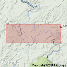
Type locality: along abandoned highway, 3.5 mi south and 1 mi east of Brady, and 0.75 mi northwest of Brook Ranch headquarters, McCulloch Co., central TX.
Source: US geologic names lexicon (USGS Bull. 1200, p. 492).
For more information, please contact Nancy Stamm, Geologic Names Committee Secretary.
Asterisk (*) indicates published by U.S. Geological Survey authors.
"No current usage" (†) implies that a name has been abandoned or has fallen into disuse. Former usage and, if known, replacement name given in parentheses ( ).
Slash (/) indicates name conflicts with nomenclatural guidelines (CSN, 1933; ACSN, 1961, 1970; NACSN, 1983, 2005, 2021). May be explained within brackets ([ ]).