The National Geologic Map Database is migrating to a new infrastructure. We apologize for any service disruptions during this process.
|
|---|


- Usage in publication:
-
- Brock Canyon Formation*
- Modifications:
-
- Principal reference
- Age modified
- Biostratigraphic dating
- Dominant lithology:
-
- Claystone
- Arkose
- Dolomite
- Conglomerate
- AAPG geologic province:
-
- Great Basin province
Summary:
Pg. 6-14, 83-93, pI. 1. Brock Canyon Formation. Consists of about 5,000 feet of near-shore marine and nonmarine sedimentary rocks, which was deposited unconformably on deformed eugeosynclinal rocks of Ordovician Valmy Formation, part of allochthonous upper plate of Roberts thrust (Late Devonian to Early Pennsylvanian). Comprises four informal members (ascending): conglomerate member, dolomite member, claystone member, and arkose member. Contact with underlying Valmy greatly modified by shearing during Early Cretaceous(?) episode of pluton intrusion; near type section, unconformably overlies Ordovician Vinini Formation. Age is considered Late Pennsylvanian or Permian, based on fossils (plants) collected from base of dolomite member. The two upper members are unfossiliferous and may be of early Mesozoic age. Formation named by [Gilluly and Gates, 1965, USGS Prof. Paper 465] in Crescent Valley quadrangle. Only lower few hundred feet of formation exposed in that quadrangle. Type locality and supplementary sections designated in area of present report. Report includes geologic map, measured sections.
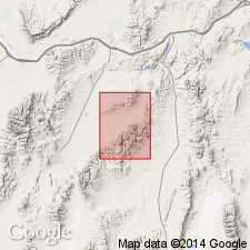
Type section: in upper part of Cottonwood Canyon, Frenchie Creek and Horse Creek Valley quadrangles, Eureka Co., NV. Section measured from E. 277,859, N. 2,006,900 to E. 271,850, N. 2,002,550.
Supplementary section 1: east side of Brock Canyon near the mouth from E. 245,700, N. 2,015,200 to E. 247,450, N. 2,014,450, Frenchie Creek 15-min quadrangle, Eureka Co., NV.
Supplementary section 2: west side of Brock Canyon near the mouth from E. 245,450, N. 2,012,800 to E. 244,500, N. 2,012,250, [border Crescent Valley and Frenchie Creek 15-min quadrangles], Eureka Co., NV.
Source: Publication; US geologic names lexicon (USGS Bull. 1350, p. 91-92); GNU records (USGS DDS-6; Menlo GNULEX).
- Usage in publication:
-
- Brock Canyon Formation*
- Modifications:
-
- Named
- Biostratigraphic dating
- Mapped
- Dominant lithology:
-
- Dolomite
- Conglomerate
- Sandstone
- Limestone
- AAPG geologic province:
-
- Great Basin province
Summary:
Pg. 9 (table 1), 44-45, pl. 1 (geol. map), pl. 3 (corr. chart), pl. 4 (fossil locs.). Brock Canyon Formation. Consists of dolomite (lower member), conglomerate (middle member), and sandstone and limestone (upper member). Total thickness in Crescent Valley quadrangle, 1,200 to 1,500 feet. In fault contact with underlying Valmy Formation. Age is considered Late Pennsylvanian or Early Permian, based on two small fossil (plants, mollusks) collections. Report includes geologic map, faunal list, correlation chart.
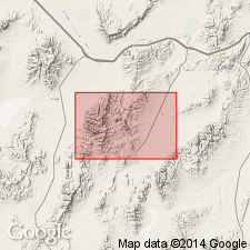
Named from exposures in Brock Canyon on northwest face of Cortez Mountains in and east of southeast corner of Crescent Valley 15-min quadrangle, Eureka Co., NV.
Source: Publication; US geologic names lexicon (USGS Bull. 1350, p. 91-92); GNU records (USGS DDS-6; Menlo GNULEX).
For more information, please contact Nancy Stamm, Geologic Names Committee Secretary.
Asterisk (*) indicates published by U.S. Geological Survey authors.
"No current usage" (†) implies that a name has been abandoned or has fallen into disuse. Former usage and, if known, replacement name given in parentheses ( ).
Slash (/) indicates name conflicts with nomenclatural guidelines (CSN, 1933; ACSN, 1961, 1970; NACSN, 1983, 2005, 2021). May be explained within brackets ([ ]).