

- Usage in publication:
-
- Bridwell formation
- Modifications:
-
- Original reference
- Dominant lithology:
-
- Sand
- Clay
- Gravel
- AAPG geologic province:
-
- Permian basin
Summary:
Pg. 4 (table 1), 6-7. Bridwell formation. Bedded, unconsolidated sand and clay with thick channel gravel occurring both at base and at higher levels; characteristically reddish brown; locally a few gray highly calcareous members, including caliche cap rock. Thickness at type locality 155 feet; locally pinches out against higher relief features on bed rock surface which extends well above upper level of Couch formation (new). Underlies Blanco formation. [Age is middle Pliocene.]
Typically exposed on Fowler Ranch, 10 mi north of Crosbyton, Crosby Co., western TX. Named from Bridwell Ranch in Blanco Canyon.
Source: US geologic names lexicon (USGS Bull. 1200, p. 477).
- Usage in publication:
-
- Bridwell formation
- Modifications:
-
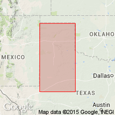
- Areal extent
- AAPG geologic province:
-
- Permian basin
Van Siclen, D.C., 1957, Cenozoic strata on the southwestern Osage Plains of Texas: Journal of Geology, v. 65, no. 1, p. 47-60.
Summary:
Pg. 49 (fig. 2), 51, 52. Bridwell formation. Quartzitic sand and fine gravel. Thickness 75 feet. Lies above Couch formation. Stratigraphic section (fig. 2) lists formation under heading Pliocene (and Miocene?). Recognized only on Llano Estacado.
Source: Publication; US geologic names lexicon (USGS Bull. 1200, p. 477).

- Usage in publication:
-
- Bridwell Member
- Modifications:
-
- [Revised]
- AAPG geologic province:
-
- Permian basin
Summary:
Bridwell Member of Ogallala Formation. Not separately mapped. [Reduced in rank to member of Ogallala Formation. See entry under Ogallala.]
Source: Publication.
For more information, please contact Nancy Stamm, Geologic Names Committee Secretary.
Asterisk (*) indicates published by U.S. Geological Survey authors.
"No current usage" (†) implies that a name has been abandoned or has fallen into disuse. Former usage and, if known, replacement name given in parentheses ( ).
Slash (/) indicates name conflicts with nomenclatural guidelines (CSN, 1933; ACSN, 1961, 1970; NACSN, 1983, 2005, 2021). May be explained within brackets ([ ]).