The National Geologic Map Database is migrating to a new infrastructure. We apologize for any service disruptions during this process.
|
|---|


- Usage in publication:
-
- Bridport dolomite
- Modifications:
-
- Named
- Dominant lithology:
-
- Dolomite
- Limestone
- AAPG geologic province:
-
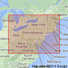
- New England province
Summary:
Bridport dolomite, here named, corresponds to Division E of "Calciferous" of Brainerd and Seely (1890: Am. Mus. Nat. History Bull, v. 3). Includes beds of fine-grained dolomite, 1 or 2 feet thick, weathering drab, yellowish, or brown. Occasional fossiliferous pure limestone layers. Rarely thin layers of slate. Maximum thickness 500 feet. Underlies Crown Point limestone; conformably overlies Bascom formation (new name). Upper contact of Bridport is in most places a distinct stratigraphic break, above which may be any of the formations of the Chazy or Black River-Trenton that crop out in area occupied by Bridport. Age is Early Ordovician.
Source: GNU records (USGS DDS-6; Reston GNULEX).
- Usage in publication:
-
- Bridport Dolostone Member
- Modifications:
-
- Revised
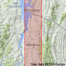
- Areal extent
- AAPG geologic province:
-
- New England province
Summary:
Bridport Dolostone Member here assigned to Providence Island Formation rather than Chipman Formation. Providence Island has precedence and furthermore is in keeping with current NY terminology. Unit occurs west of the ledges in Cornwall and Weybridge, while Beldens Dolostone Member is present from Cornwall Ledges eastward.
Source: GNU records (USGS DDS-6; Reston GNULEX).
For more information, please contact Nancy Stamm, Geologic Names Committee Secretary.
Asterisk (*) indicates published by U.S. Geological Survey authors.
"No current usage" (†) implies that a name has been abandoned or has fallen into disuse. Former usage and, if known, replacement name given in parentheses ( ).
Slash (/) indicates name conflicts with nomenclatural guidelines (CSN, 1933; ACSN, 1961, 1970; NACSN, 1983, 2005, 2021). May be explained within brackets ([ ]).