

- Usage in publication:
-
- Brandywine formation*
- Modifications:
-
- Original reference
- Dominant lithology:
-
- Sand
- Gravel
- AAPG geologic province:
-
- Atlantic Coast basin
Summary:
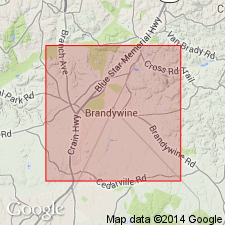
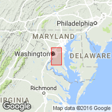
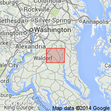
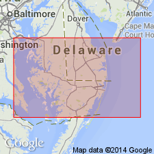
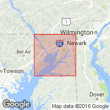
Pg. 499, 506. The recognition by the USGS and the various State Surveys in Atlantic border area of the inappropriateness of the term Lafayette as employed in Atlantic border region has led to proposal by author of name Brandywine for the oldest of the terrace formations of the district. This name has already been submitted to Board of Geologic Names of USGS and adopted by it. The name Brandywine is proposed for this formation because the deposits are extensively and typically developed in vicinity of Brandywine, Prince George's County, Maryland. The terms Appomattox and Lafayette as originally employed in Middle Atlantic Coastal Plain embraced much more than it is proposed to include under the name Brandywine formation, the diagnosis of which is based on different physiographic conceptions from those used by McGee and Darton. The Brandywine formation covers extensive area in southern Maryland peninsula reaching from east boundary of DC to north line of St. Mary's County, Maryland, with numerous outliers to north and to south of these lines. It attains maximum width from northwest to southeast of nearly 40 miles. It extends northward into Delaware and Pennsylvania and has been traced southward through Virginia into the Carolinas. Altitude of landward boundary reaches 400 feet in outliers in western part of DC; 486 feet at Burtonsville, Montgomery County, Maryland; 508 feet at Catonsville, and 480 feet at Loch Raven, Baltimore County; and 470 feet at Woodlawn, Cecil County. Each of these outliers is extensively eroded ad isolated from main body of the formation farther seaward. The altitude of the formation along the seaward boundary in northern St. Mary's County is not over 200 feet, while farther northward in Maryland, elevations of 240 feet are found at Marriott Hill, Anne Arundel County, and 300 feet on Elk Neck, Cecil County. The formation is composed of gravel, sand, and loam. Over considerable areas the gravel occurs in great abundance at the base. Thickness of formation 10 to 30 feet, the thickness for most part increasing from the landward toward the seaward margin of the formation. Exceptional thicknesses of over 50 feet have been found. No determinable fossils have been found in type area. The formation unconformably overlies all older Coastal Plain formations of Tertiary and Cretaceous age, and at a few places rests on crystalline rocks. Throughout much of the region it is separated from next younger (Sunderland) formation by a clearly marked escarpment and unconformity. Brandywine, Prince George's County, Maryland, is located on the slightly eroded surface of the old Brandywine terrace not far from center of largest tract still preserved intact. Maximum thickness of formation is in general area in which Brandywine is situated. The adjacent ravines to east and west of Brandywine cut through the formation. Most authors have referred these deposits to Pliocene, but author questions whether they may not with equal propriety be referred to early Pleistocene.
Source: US geologic names lexicon (USGS Bull. 896, p. 252-253).
- Usage in publication:
-
- Brandywine formation*
- Modifications:
-
- Age modified
- AAPG geologic province:
-
- Atlantic Coast basin
Summary:
Pg. 12, and 1921 (Jour. Geol., v. 29, p. 540-559). The Brandywine formation includes sand and marl of two levels and of different ages. The early Brandywine consists of about 50 feet of sand and gravel lying at altitudes of 200 to 400 feet, and is believed to be of Pleistocene or late Tertiary age. The late Brandywine consists of about 1 foot of sand and gravel lying at altitudes of 390 to 500 feet and is thought to be a terrestrial deposit of Pleistocene streams.
Source: US geologic names lexicon (USGS Bull. 896, p. 252-253).
- Usage in publication:
-
- Brandywine formation*
- Modifications:
-
- Revised
- AAPG geologic province:
-
- Atlantic Coast basin
Summary:
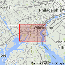
Pg. 117-119. The early Brandywine gravels are found in Elkton-Wilmington district at altitude of 380 feet, capping Egg Hill and other outstanding hills on western border of Elkton quadrangle. The late Brandywine gravels lie at altitudes of 220 feet or more. The deposit at the type locality in Maryland is the low level (200 to 300 feet) or late Brandywine, presumably of Pleistocene age. The high-level gravels (390 to 480 feet) are presumably of Pliocene age. Such a time interval between the early and late gravels as is now recognized has made it infeasible to treat the deposits as a unit. It is therefore proposed to restrict the term Brandywine formation to the late or lower-level deposits of the type locality, and to reinstate the old term Bryn Mawr gravel for the early or high-level deposits of Pennsylvania, Delaware, and Maryland (Cecil County).
Source: US geologic names lexicon (USGS Bull. 896, p. 252-253).

- Usage in publication:
-
- Brandywine formation*
- Modifications:
-
- Overview
- AAPG geologic province:
-
- Atlantic Coast basin
Summary:
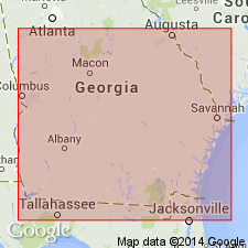
C.W. Cooke, 1931 (Washington Acad. Sci. Jour., v. 21, p. 503-513), suggested that Brandywine formation be restricted to the 270-foot level, but there is not unanimity of opinion in regard to this matter. The terrace formations of Columbia group (including the Brandywine) now recognized by Cooke across the Atlantic Coastal Plain from Delaware to southern Georgia and probably into Florida, are enumerated herein under Columbia group. Age is Pleistocene.
Source: US geologic names lexicon (USGS Bull. 896, p. 252-253).
- Usage in publication:
-
- Brandywine gravel*
- Modifications:
-
- Revised
- Age modified
- AAPG geologic province:
-
- Atlantic Coast basin
Summary:
Unit described in Prince Georges Co., MD, and DC. Because gravel is predominant component in this area, term gravel is preferred rather than formation. Gravel is commonly overlain by silt. Thickness about 40 ft. Main body lies unconformably on Chesapeake group; outliers in DC overlap the Miocene and lie on Patuxent formation and crystalline rocks. Because Brandywine lies on Chesapeake group, it must be younger than Miocene, unless, possibly it was deposited during concluding part of that epoch. Because it is highest extensive sheet of river gravel in which present Potomac Valley has been cut, it presumably antedates the Pleistocene era. No fossils have been found to verify age assignment. Unit is here referred to as Pliocene. [It is assumed that author retracts his assignment of this unit to the Columbia group, as the Columbia is Pleistocene in age.]
Source: GNU records (USGS DDS-6; Reston GNULEX).
- Usage in publication:
-
- Brandywine formation*
- Modifications:
-
- Areal extent
- AAPG geologic province:
-
- Atlantic Coast basin
Summary:
Unit is described in Brandywine area where it forms surface of the uplands and consists of lower gravel member 10 to 50 ft thick and upper loam member that averages 15 ft in thickness. Overlies North Keys sand (new), which had been mapped as part of the Brandywine by some workers and as part of the Sunderland by others. Base of formation is defined by lowest gravel or coarse sand in the section, even though beds of fine sand identical with the North Keys occur in many places interbedded with the gravel. Although formation as here defined may contain a disconformity and hiatus above the base, it is believed that this definition is only one practical for areal mapping and conforms closely to original definition. No basis is found for separating the Brandywine from the Sunderland. Both formations at their type localities are underlain by North Keys sand of Miocene(?) age. Age given as Pliocene(?) although field evidence justifies only statement that it may be Miocene, Pliocene, or Pleistocene.
Source: GNU records (USGS DDS-6; Reston GNULEX).
- Usage in publication:
-
- Brandywine Formation*
- Modifications:
-
- Age modified
- AAPG geologic province:
-
- Atlantic Coast basin
Summary:
Brandywine Formation is shown west of the Chesapeake Bay only, in uplands of MD, and adjacent DC and VA. Unit may be time equivalent of Pensauken Formation (DE) or Bridgeton Formation (NJ). Age given as Miocene.
Source: GNU records (USGS DDS-6; Reston GNULEX).
- Usage in publication:
-
- Brandywine Formation†
- Brandywine terrace
- Modifications:
-
- Abandoned
- AAPG geologic province:
-
- Atlantic Coast basin
Summary:
Author states, "* * * concepts of Silver Bluff, Princess Anne, Pamlico, Talbot, Penholoway, Wicomico, Sunderland, Coharie, and Brandywine Formations are invalid, and these names should be abandoned in the lithostratigraphic sense; most names are retained for marine terraces."
Source: GNU records (USGS DDS-6; Reston GNULEX).
- Usage in publication:
-
- Brandywine Formation
- Modifications:
-
- Not used
- AAPG geologic province:
-
- Atlantic Coast basin
Summary:
Bryn Mawr, Brandywine, and Sunderland gravels here referred to collectively as Upland Gravel (after Cleaves and others, 1968 geol. map of MD, and Owens, 1969). Was mapped as "Gravel of High Plateau" by Darton (1939). Talbot Formation is retained as a separate unit.
[This manuscript was reviewed by the GNU in 1973, but was not published until 1990. There is no record of the Upland Gravel in the GNU files from that review, and it is assumed that this section of manuscript was added or altered post-review. Therefore, the Upland Gravel is not considered formal USGS usage though named in this report. (USGS DDS-6; Reston GNULEX)]
Source: GNU records (USGS DDS-6; Reston GNULEX).
For more information, please contact Nancy Stamm, Geologic Names Committee Secretary.
Asterisk (*) indicates published by U.S. Geological Survey authors.
"No current usage" (†) implies that a name has been abandoned or has fallen into disuse. Former usage and, if known, replacement name given in parentheses ( ).
Slash (/) indicates name conflicts with nomenclatural guidelines (CSN, 1933; ACSN, 1961, 1970; NACSN, 1983, 2005, 2021). May be explained within brackets ([ ]).