

- Usage in publication:
-
- Bradford Group
- Modifications:
-
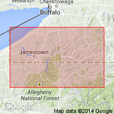
- Areal extent
- AAPG geologic province:
-
- Appalachian basin
Summary:
Bradford Group. Informal drillers' term for Upper Devonian sands in subsurface of northwestern Pennsyvlania. Includes seven sand zones (ascending): (1) lower Kane; (2) Lewis Run; (3) Bradford Third / Richburg / Rushford / Alfred Station Coquinite; (4) Bradford Second / Cooper(?) / Scholes; (5) Clarendon / Chipmunk; (6) Queen / Glade / Bradford First /Cuba; and (7) Warren Second. Approximately equivalent to Canadaway Formation of New York. Underlies "Pink Rock" (C-shale zone) and overlies Venango Group. [Despite capitalization of rank term, author makes it clear that terminology is informal.]
Source: Modified from GNU records (USGS DDS-6; Reston GNULEX).
For more information, please contact Nancy Stamm, Geologic Names Committee Secretary.
Asterisk (*) indicates published by U.S. Geological Survey authors.
"No current usage" (†) implies that a name has been abandoned or has fallen into disuse. Former usage and, if known, replacement name given in parentheses ( ).
Slash (/) indicates name conflicts with nomenclatural guidelines (CSN, 1933; ACSN, 1961, 1970; NACSN, 1983, 2005, 2021). May be explained within brackets ([ ]).