The National Geologic Map Database is migrating to a new infrastructure. We apologize for any service disruptions during this process.
|
|---|


- Usage in publication:
-
- Bowes member
- Modifications:
-
- Original reference
- Dominant lithology:
-
- Limestone
- Sandstone
- AAPG geologic province:
-
- Williston basin
Summary:
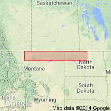
Pg. 97, 102-103. Bowes member of Piper formation. Displays varying lithologies, being represented in Williston basin by red to varicolored shale facies which grade westward into sandstone and sandy oolitic limestone on east flank of Sweetgrass arch. In type section, consists of (descending) 18 feet of light-brown finely crystalline to fragmental limestone, very sandy to argillaceous in part with few thin stringers of light-gray calcareous sandstone; 7 feet of light-gray fine- to coarse-grained very calcareous sandstone; 20 feet of light-gray oolitic to sandy limestone with thin beds of calcareous sandstone; and 12 feet of light-brown fine-grained calcareous sandstone grading downward into light-gray sandy and partly oolitic limestone. Becomes increasingly sandy and somewhat variable in thickness west of type well; eastward becomes interbedded with shale and eventually grades into varicolored shale, thickness uniform. Conformably overlies Firemoon limestone member (new) in Williston basin and most of north-central Montana; southward it overlaps Firemoon member and unconformably overlies Madison limestone. Underlies Rierdon formation. Occurs in central and eastern Montana (subsurface and surface). Age is Middle Jurassic.
Type section (subsurface): depth-interval 3,360 to 3,417 ft, Northern Ordinance No. 1 Guertzgen well, in SW/4 NW/4 NE/4 sec. 2, T. 31 N., R. 19 E., Blaine Co., MT. Named from Bowes oil field.
Source: US geologic names lexicon (USGS Bull. 1200, p. 442).

- Usage in publication:
-
- Bowes Member*
- Modifications:
-
- Overview
- AAPG geologic province:
-
- Williston basin
Summary:
Member of Piper Formation in central and eastern MT and western ND in Williston basin. Summarizes lithology, basis for dating, distribution, and correlation. Is Middle Jurassic (Bathonian) in age.
Source: GNU records (USGS DDS-6; Denver GNULEX).
For more information, please contact Nancy Stamm, Geologic Names Committee Secretary.
Asterisk (*) indicates published by U.S. Geological Survey authors.
"No current usage" (†) implies that a name has been abandoned or has fallen into disuse. Former usage and, if known, replacement name given in parentheses ( ).
Slash (/) indicates name conflicts with nomenclatural guidelines (CSN, 1933; ACSN, 1961, 1970; NACSN, 1983, 2005, 2021). May be explained within brackets ([ ]).