The National Geologic Map Database is migrating to a new infrastructure. We apologize for any service disruptions during this process.
|
|---|


- Usage in publication:
-
- Bowers Quartz Diorite
- Modifications:
-
- Named
- Dominant lithology:
-
- Quartz diorite
- AAPG geologic province:
-
- Okanogan province
Summary:
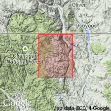
Bowers Quartz Diorite. Name proposed for unit in /Horseshoe Basin magma series [informal] (new). Mapped in T. 39 N., R. 25 E., Toats Coulee Creek region, Okanogan Range, Okanogan County, Washington. Is a light-gray to blue-gray, fine to medium grained quartz diorite pluton. Contains euhedral biotite and locally slender hornblende crystals. Age is Early to medial Cretaceous.
Type locality stated to be in T. 39 N., R. 25 E., Okanogan Co., WA. Origin of name not stated.
["Horseshoe Basin magma series" considered informal. Term "Series" is applied formally only to chronostratigraphic units (ACSN, 1961, 1970; NACSN, 1983, 2005, 2021). US geologic names lexicon (USGS Bull. 1520, p. 36) lists Bowers Quartz Diorite of Horseshoe Basin Group (explanation not given).]
Source: GNU records (USGS DDS-6; Menlo GNULEX); supplemental information from US geologic names lexicon (USGS Bull. 1520, p. 36).
For more information, please contact Nancy Stamm, Geologic Names Committee Secretary.
Asterisk (*) indicates published by U.S. Geological Survey authors.
"No current usage" (†) implies that a name has been abandoned or has fallen into disuse. Former usage and, if known, replacement name given in parentheses ( ).
Slash (/) indicates name conflicts with nomenclatural guidelines (CSN, 1933; ACSN, 1961, 1970; NACSN, 1983, 2005, 2021). May be explained within brackets ([ ]).