The National Geologic Map Database is migrating to a new infrastructure. We apologize for any service disruptions during this process.
|
|---|


- Usage in publication:
-
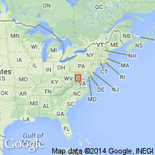
- Botetourt limestone member
- Modifications:
-
- Named
- Dominant lithology:
-
- Limestone
- AAPG geologic province:
-
- Appalachian basin
Summary:
Named the Botetourt limestone member of the Edinburg formation for Botetourt Co., VA. Consists of brown weathering, granular limestone that directly overlies the Lincolnshire formation and underlies the Liberty Hall type lithology of the Edinburg formation. Thickness at type section is 15 to 75 feet.
Source: GNU records (USGS DDS-6; Reston GNULEX).
- Usage in publication:
-
- Botetourt formation
- Modifications:
-
- Revised
- Areal extent
- Biostratigraphic dating
- AAPG geologic province:
-
- Appalachian basin
Summary:
Pg. 49-50, chart 1 (facing p. 130). Botetourt formation. Rank raised to formation. In Catawba Valley northeast of Blacksburg, underlies or interfingers with calcarenites of Effna formation. At Edinburg dam section about 1 mile below Edinburg and at Tumbling Run section 1.5 miles southwest of Strasburg, Virginia, dark thin-bedded limestone occurs between granular beds thought to be Botetourt and the cherty Lincolnshire; these beds are here placed in Botetourt formation. Can be recognized in parts of Tennessee as at type section of the Whitesburg of Ulrich, where it overlies the Lenoir formation and underlies the Whitesburg formation.
Source: US geologic names lexicon (USGS Bull. 1200, p. 437-438).
For more information, please contact Nancy Stamm, Geologic Names Committee Secretary.
Asterisk (*) indicates published by U.S. Geological Survey authors.
"No current usage" (†) implies that a name has been abandoned or has fallen into disuse. Former usage and, if known, replacement name given in parentheses ( ).
Slash (/) indicates name conflicts with nomenclatural guidelines (CSN, 1933; ACSN, 1961, 1970; NACSN, 1983, 2005, 2021). May be explained within brackets ([ ]).