

- Usage in publication:
-
- Boone Creek limestone
- Modifications:
-
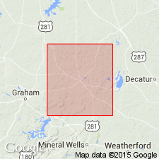
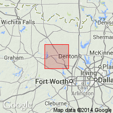
- Areal extent
- Dominant lithology:
-
- Limestone
- AAPG geologic province:
-
- Fort Worth syncline
Summary:
Boone Creek limestone, 5+/- feet thick, is in Palo Pinto formation, and Willow Point limestone is in Graford formation, 40+/- feet above Bridgeport coal. [Age is Pennsylvanian.]
Source: US geologic names lexicon (USGS Bull. 896, p. 236-237).
- Usage in publication:
-
- Boone Creek limestone
- Modifications:
-
- Areal extent
- AAPG geologic province:
-
- Fort Worth syncline
Sellards, E.H., 1931, [Discussion in News Letter, September, 1931]: University of Texas-Austin, Bureau of Economic Geology
Summary:
In Wise County [central northern Texas] the Palo Pinto limestone has been found to be divided into 2 thin limestones separated by shale. The limestones are named Boone Creek and Willow Point. [Age is Pennsylvanian.]
Source: US geologic names lexicon (USGS Bull. 896, p. 236-237).
- Usage in publication:
-
- Boone Creek limestone
- Modifications:
-
- Areal extent
- AAPG geologic province:
-
- Fort Worth syncline
Summary:
Pg. 23. Boone Creek limestone included in Palo Pinto formation. [Age is Pennsylvanian.]
Source: US geologic names lexicon (USGS Bull. 896, p. 236-237).

- Usage in publication:
-
- Boone Creek limestone
- Modifications:
-
- Overview
- AAPG geologic province:
-
- Fort Worth syncline
Summary:
Pg. 105. Boone Creek limestone in Palo Pinto formation, is named from Boone Creek, Jack County, central northern Texas.
[Boone Creek limestone member of Palo Pinto limestone of Pennsylvanian age adopted by the USGS. Recognized in Jack and Wise Counties, Brazos River region, central northern Texas.]
Source: US geologic names lexicon (USGS Bull. 896, p. 236-237).
For more information, please contact Nancy Stamm, Geologic Names Committee Secretary.
Asterisk (*) indicates published by U.S. Geological Survey authors.
"No current usage" (†) implies that a name has been abandoned or has fallen into disuse. Former usage and, if known, replacement name given in parentheses ( ).
Slash (/) indicates name conflicts with nomenclatural guidelines (CSN, 1933; ACSN, 1961, 1970; NACSN, 1983, 2005, 2021). May be explained within brackets ([ ]).