The National Geologic Map Database is migrating to a new infrastructure. We apologize for any service disruptions during this process.
|
|---|


- Usage in publication:
-
- Bonita Springs Marl Member
- Modifications:
-
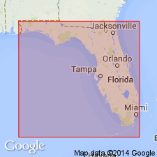
- Areal extent
- Dominant lithology:
-
- Marl
- AAPG geologic province:
-
- Florida platform
Summary:
Name was informally suggested for member of the Tamiami Formation by Missimer (1984). Unit can be mapped over 100 sq mi in southwest Lee Co. and northwest Collier Co. It consists of green dolosilt in the vicinity of Bonita Springs, but contains a large variety of different lithologies all of which contain a lime mud or dolosilt matrix. Locally, the lithology is similar to the uppermost part of the Peace River Formation of the Hawthorn Group. Microfossils are absent, but unit does contain several barnacles. Would probably be mapped as part of the Peace River if it did not lie between the unnamed limestone facies and the Ochopee Limestone Member of the Tamiami Formation.
Source: GNU records (USGS DDS-6; Reston GNULEX).
For more information, please contact Nancy Stamm, Geologic Names Committee Secretary.
Asterisk (*) indicates published by U.S. Geological Survey authors.
"No current usage" (†) implies that a name has been abandoned or has fallen into disuse. Former usage and, if known, replacement name given in parentheses ( ).
Slash (/) indicates name conflicts with nomenclatural guidelines (CSN, 1933; ACSN, 1961, 1970; NACSN, 1983, 2005, 2021). May be explained within brackets ([ ]).