- Usage in publication:
-
- Bluebonnet member
- Modifications:
-
- Original reference
- Dominant lithology:
-
- Limestone
- Shale
- Bentonite
- AAPG geologic province:
-
- Ouachita folded belt
Summary:
Pg. 122-123, 139 (fig. 17), 141 (fig. 18). Bluebonnet member of Lake Waco formation. Consists of limestone flagstones interbedded with calcareous shale and bentonites. Thickness 12 to 18 feet. Underlies Cloice member (new); overlies Pepper formation. Age is Cretaceous (Gulf series).
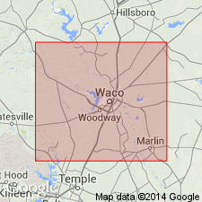
Type area: along Bosque escarpment from old South Bosque brickyard southwest into Moody Hills, then southward past Moody, McLennan Co., central TX.
Type section: opposite Baggets Station, on east side of McGregor-Moody Road (TX Highway 17), about 4.5 mi south-southeast of McGregor, McLennan Co., central TX.
Source: US geologic names lexicon (USGS Bull. 1200, p. 393).
For more information, please contact Nancy Stamm, Geologic Names Committee Secretary.
Asterisk (*) indicates published by U.S. Geological Survey authors.
"No current usage" (†) implies that a name has been abandoned or has fallen into disuse. Former usage and, if known, replacement name given in parentheses ( ).
Slash (/) indicates name conflicts with nomenclatural guidelines (CSN, 1933; ACSN, 1961, 1970; NACSN, 1983, 2005, 2021). May be explained within brackets ([ ]).

