

- Usage in publication:
-
- Blue Creek coal member
- Modifications:
-
- Original reference
- AAPG geologic province:
-
- Illinois basin
Summary:
Pg. 25, 72. Blue Creek coal member of Mansfield formation. Important marker bed in upper part of Mansfield in Huron area. Thickness 4 feet 8 inches at type section. Lies approximately 100 feet above base of upper Mansfield in a sequence of sandstones with wavy bedding. Age is Pennsylvanian.
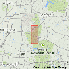
Type section: in abandoned strip mine at west end of ridge, in SW/4 NW/4 sec. 10, T. 1 N., R. 3 W., Martin Co., south-central IN. Named from exposures at headwaters of Blue Creek.
Source: US geologic names lexicon (USGS Bull. 1200, p. 394).

- Usage in publication:
-
- Blue Creek Coal Member
- Modifications:
-
- Overview
- AAPG geologic province:
-
- Illinois basin
Summary:
Pg. 16, pls. Blue Creek Coal Member of Mansfield Formation of Raccoon Creek Group. Coal. Comprises an upper bench, dull banded and slightly fissile to shaly, 2 feet (0.6 m) thick, and a lower bench, bright banded and blocky to hackly, 2.8 feet (0.8 m) thick. Roof is 8 feet (2.4 m) of dark-gray carbonaceous ferruginous shale overlain by 6.5 feet (2.0 m) of yellow-brown to light-gray sandstone; floor is white fire clay. Lies some 60 to 80 feet (18 to 24 m) below top of Mansfield and about 100 feet (30 m) above Pinnick Coal Member. Present in Martin, Dubois, Daviess, and Perry Counties, south-central Indiana. Age is Early Pennsylvanian (Morrowan). Report includes map of type sections-localities-areas, correlation chart.
Source: Publication.
For more information, please contact Nancy Stamm, Geologic Names Committee Secretary.
Asterisk (*) indicates published by U.S. Geological Survey authors.
"No current usage" (†) implies that a name has been abandoned or has fallen into disuse. Former usage and, if known, replacement name given in parentheses ( ).
Slash (/) indicates name conflicts with nomenclatural guidelines (CSN, 1933; ACSN, 1961, 1970; NACSN, 1983, 2005, 2021). May be explained within brackets ([ ]).