The National Geologic Map Database is migrating to a new infrastructure. We apologize for any service disruptions during this process.
|
|---|


- Usage in publication:
-
- Blue Creek Canyon group
- Modifications:
-
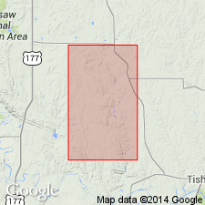
- Areal extent
- Dominant lithology:
-
- Limestone
- Dolomite
- AAPG geologic province:
-
- South Oklahoma folded belt
Summary:
Pg. 19. Blue Creek Canyon group. Name used to include (ascending) Fort Sill limestone, Royer dolomite, Signal Mountain limestone, and Butterly dolomite [all of Arbuckle group]. Overlies Timbered Hills group. Age is Cambrian. Name credited to E.A. Frederickson (unpub. thesis).
[Origin of name not stated.]
Source: US geologic names lexicon (USGS Bull. 1200, p. 394).
For more information, please contact Nancy Stamm, Geologic Names Committee Secretary.
Asterisk (*) indicates published by U.S. Geological Survey authors.
"No current usage" (†) implies that a name has been abandoned or has fallen into disuse. Former usage and, if known, replacement name given in parentheses ( ).
Slash (/) indicates name conflicts with nomenclatural guidelines (CSN, 1933; ACSN, 1961, 1970; NACSN, 1983, 2005, 2021). May be explained within brackets ([ ]).