The National Geologic Map Database is migrating to a new infrastructure. We apologize for any service disruptions during this process.
|
|---|


- Usage in publication:
-
- Blossburg formation
- Modifications:
-
- Areal extent
- Dominant lithology:
-
- Sandstone
- Shale
- Limestone
- AAPG geologic province:
-
- Appalachian basin
Summary:
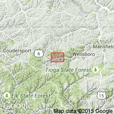
Pg. 585, 593. The term "Bloomsburg formation" has been applied by drillers to the source of supply of the oil the wells of the Manhattan group, 1 mile east of Gaines [Tioga County, central northern Pennsylvania]. It is a series of alternating sands, shales, and shaly limestones, of which certain of the more sandy members have produced oil. Top, though somewhat variable, is about 200 feet above horizon of Atwell sand. Included in Chemung formation. Age is Late Devonian.
Source: US geologic names lexicon (USGS Bull. 896, p. 215).
For more information, please contact Nancy Stamm, Geologic Names Committee Secretary.
Asterisk (*) indicates published by U.S. Geological Survey authors.
"No current usage" (†) implies that a name has been abandoned or has fallen into disuse. Former usage and, if known, replacement name given in parentheses ( ).
Slash (/) indicates name conflicts with nomenclatural guidelines (CSN, 1933; ACSN, 1961, 1970; NACSN, 1983, 2005, 2021). May be explained within brackets ([ ]).