

- Usage in publication:
-
- Bloodgood Canyon Rhyolite
- Modifications:
-
- Named
- Geochronologic dating
- Dominant lithology:
-
- Rhyolite
- AAPG geologic province:
-
- Basin-and-Range province
Summary:
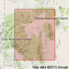
Name applied to a massive ash-flow compound cooling unit characterized by conspicuous phenocrysts of rounded quartz and sanidine cryptoperthite. Biotite is scarce. Pumice fragments nearly spherical in shape are conspicuous at top; grade into flattened and elongated streaks near base. Is at least 2,000 feet thick in its source cauldron (of which Diablo Range and Jerky Mountains form the western rim). Distal edge located in Pinos Altos and Silver City ranges. Extent to north is unknown. Entire sheet has a minimum diameter of 85 miles. Has conflicting age dates of 26.3 +/-0.8 and 23.2 +/-0.7 Ma. Assigned a Tertiary age. Shown on figure 2 as older than Jerky Mountain Rhyolite. Its suspected source cauldron is the Gila Cliff Dwellings cauldron.
Type locality not designated. Named from Bloodgood Canyon, a tributary of Little Creek in northeastern flank of Diablo Range, in secs. 5 and 6, T. 13 S., R. 14 W., Grant Co., NM [Basin-and-Range province].
Source: Modified from GNU records (USGS DDS-6; Denver GNULEX).
- Usage in publication:
-
- Bloodgood Canyon Rhyolite
- Modifications:
-
- Paleomagnetics
- AAPG geologic province:
-
- Basin-and-Range province
Summary:
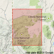
At the mouth of Gila Canyon, Grant County, New Mexico [Basin-and-Range province], Bloodgood Canyon Rhyolite is well exposed in the canyon walls, and is overlain by a thick sequence of basalt. Both the Bloodgood Canyon Rhyolite and the basalt are reversely magnetized. Magnetostratigraphic position of Bloodgood Canyon unit within a preliminary model of the middle Tertiary paleomagnetic reversal pattern is depicted on figs. 4 and 5.
Source: Modified from GNU records (USGS DDS-6; Denver GNULEX).
- Usage in publication:
-
- Bloodgood Canyon Tuff*
- Modifications:
-
- Overview
- Reference
- Geochronologic dating
- Dominant lithology:
-
- Tuff
- AAPG geologic province:
-
- Basin-and-Range province
Summary:
Bloodgood Canyon Tuff of Elston (1968) adopted by the USGS. Is a high-silica rhyolite ash-flow tuff containing 10 to 30 percent phenocrysts of mainly cryptoperthite and quartz with trace amounts of sodic plagioclase. Accessory minerals include sphene, opaque oxide, rare biotite, oxyhornblende, zircon, apatite. Forms major outflow ash-flow tuff sheet related to Bursum and Gila Cliff Dwellings calderas. Is 50 to 60 m thick in quadrangle. Is 300 m thick at type. Overlies Shelley Peak Tuff (new) or unnamed lavas. Underlies Gila Conglomerate or unnamed lavas. Silicified and argillized part in Bursum caldera wall was included in Pacific Quartz Latite (abandoned). K-Ar and fission track ages of 26 to 27 m.y. or Oligocene.
Type section is in secs. 5 and 6, T. 13 S., R. 14 W., Catron Co., NM, [Basin-and-Range province].
Reference sections: (1) in S/2 sec. 31, T. 8 S., R. 20 W., and (2) in S/2 sec. 3, T. 7 S., R. 19 W., Catron Co., NM, [Basin-and-Range province].
Source: Modified from GNU records (USGS DDS-6; Denver GNULEX).
- Usage in publication:
-
- Bloodgood Canyon Tuff*
- Modifications:
-
- Areal extent
- AAPG geologic province:
-
- Basin-and-Range province
Summary:
Replaces use of Railroad Canyon Formation in Indian Peaks area, Black Range, Grant, and Catron Counties, New Mexico [Basin-and-Range province]. Is now recognized as one of the two regional sheets that were included in the original definition of Railroad Canyon. Is 28 to 29 m.y. old.
Source: Modified from GNU records (USGS DDS-6; Denver GNULEX).
- Usage in publication:
-
- Bloodgood Canyon Tuff*
- Modifications:
-
- Areal extent
- Overview
- AAPG geologic province:
-
- Basin-and-Range province
Summary:
Is extended into Indian Peaks West quadrangle, Catron County, New Mexico [in Basin-and-Range province]. Formerly included as part of Railroad Canyon Rhyolite of Elston and others (1973), which was considered to be a major ash-flow sheet in northern Black Range, New Mexico. Railroad Canyon Rhyolite is abandoned. Detailed mapping, new age dates, and minor-element chemistry indicate that parts of tuff of Railroad Canyon are distal remnants of Bloodgood Canyon Tuff (Ratte and others, 1984). Thickness and extent variable; maximum thickness about 40 m. Age is Oligocene.
Source: Modified from GNU records (USGS DDS-6; Denver GNULEX).
- Usage in publication:
-
- Bloodgood Canyon Tuff*
- Modifications:
-
- Geochronologic dating
- AAPG geologic province:
-
- Basin-and-Range province
Summary:
Has yielded average K-Ar ages of 28.8 +/-1.3 m.y. (biotite) and 26.9 +/-1.3 m.y. (sanidine), and average F-T ages of 28.1 +/-2.2 m.y. (zircon) and 28.2 +/-2.1 m.y. (sphene). Has a 40Ar / 39Ar age of 28.36 m.y. [Oligocene age]. Sampled in Catron and Grant Counties, New Mexico, and Greenlee County, Arizona [in the Basin-and-Range province].
Source: Modified from GNU records (USGS DDS-6; Denver GNULEX).
For more information, please contact Nancy Stamm, Geologic Names Committee Secretary.
Asterisk (*) indicates published by U.S. Geological Survey authors.
"No current usage" (†) implies that a name has been abandoned or has fallen into disuse. Former usage and, if known, replacement name given in parentheses ( ).
Slash (/) indicates name conflicts with nomenclatural guidelines (CSN, 1933; ACSN, 1961, 1970; NACSN, 1983, 2005, 2021). May be explained within brackets ([ ]).