

- Usage in publication:
-
- Blakeley formation
- Modifications:
-
- Original reference
- Biostratigraphic dating
- Dominant lithology:
-
- Shale
- Sandstone
- AAPG geologic province:
-
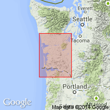
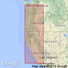
- Puget Sound province
Summary:
Pg. 10-22. Blakeley formation. Alternating shales and sandstones overlain by nearly 1,000 feet of nonfossiliferous conglomerates. Thickness of formation 8,000 feet. Fossils listed. Been considered Oligocene or at least in part Oligocene, but writer now places them in lower Miocene, until definite understanding has been reached as to what is to constitute Oligocene.
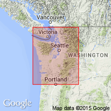
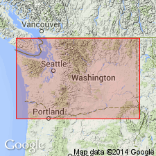
Type section: Restoration Point, opposite Seattle, Kitsap Co., west-central WA.
Source: US geologic names lexicon (USGS Bull. 896, p. 210).
- Usage in publication:
-
- Blakeley horizon
- Modifications:
-
- Principal reference
- Revised
- Biostratigraphic dating
- AAPG geologic province:
-
- Puget Sound province
Summary:
Blakeley horizon. Characterized by ACILA GETTYSBURGENSIS zone, and is assigned to Oligocene. Fossils listed. The highest strata outcrop on north shores of Blakeley Harbor. Type section is at entrance to Bremerton Navy Yard. Is younger than Porter horizon and older than Wahkiakum horizon (lower Miocene).
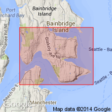
Type section: Restoration Point, Kitsap Co., west-central WA, opposite Seattle, at entrance to Bremerton Navy Yard. Highest strata crop out on north shores of Blakeley Harbor.
Source: US geologic names lexicon (USGS Bull. 896, p. 210).
- Usage in publication:
-
- Blakeley formation
- Modifications:
-
- Overview
- AAPG geologic province:
-
- Puget Sound province
Summary:
Pg. 245, 261-264. Blakeley formation. Seattle and Twin River formations of Arnold and Hannibal's Astoria series seem to be = Weaver's Blakeley formation. While later studies may show Blakeley beds (ACILA GETTYSBURGENSIS zone) to be younger, they are present considered to be upper Oligocene.
Source: US geologic names lexicon (USGS Bull. 896, p. 210).
- Usage in publication:
-
- Blakeley formation
- Modifications:
-
- Areal extent
- AAPG geologic province:
-
- Puget Sound province
Summary:
Pg. 114-115. Blakeley formation. Type section of the Blakeley comprises sandstones, shales, and conglomerates, exposed in sea cliffs along entrance to Bremerton Inlet, an arm of Puget Sound. Lowermost beds occur at Orchard Point and consist of conglomerates; uppermost strata are also composed of conglomerates cropping out at north entrance of Blakeley Harbor on southern portion of Bainbridge Island. Fossiliferous horizon within formation from which bulk of fauna of the Blakeley have been obtained, occurs at Restoration Point about one-third the thickness of the formation downward from the top. Term Blakeley was applied by Weaver (1912) to section consisting of about 8,000 feet of shales, sandstones, and conglomerates at Restoration Point. At the time that report was written, the writer [Weaver] had in mind the entire sequence of beds between Port Blakeley and Orchard Point, but as result of incomplete statement referred only to Restoration Point. Formation has thickness of 8,900 feet including about 1,800 feet of conglomerate at base and 1,300 feet of conglomerate at top. Between are 4,800 feet of massive and stratified sandy shales, and thick members of interstratified conglomerate. It is possible lower Orchard Point conglomerate (new) may belong to middle Oligocene, and represent equivalent of Lyre formation (new).
Source: US geologic names lexicon (USGS Bull. 1200, p. 380-381).
- Usage in publication:
-
- Blakeley formation
- Modifications:
-
- Biostratigraphic dating
- AAPG geologic province:
-
- Puget Sound province
Summary:
Pg. 113. Blakeley formation. Faunal studies indicate upper part of Twin River formation is younger than fossiliferous type Blakeley formation.
Source: US geologic names lexicon (USGS Bull. 1200, p. 380-381).
- Usage in publication:
-
- Blakeley stage
- Blakeley formation
- Modifications:
-
- Overview
- AAPG geologic province:
-
- Puget Sound province
Summary:
Chart 11. Shown on correlation chart as Blakeley stage and Blakeley formation.
Source: US geologic names lexicon (USGS Bull. 1200, p. 380-381).
- Usage in publication:
-
- Blakeley formation
- Modifications:
-
- Redefined
- AAPG geologic province:
-
- Puget Sound province
Summary:
Pg. 1340-1341. Blakeley formation. Weaver (1912) applied name Blakeley formation to Bainbridge Island section consisting of approximately 8,000 feet of conglomerates, sandstones, siltstones, and shales. Later, Weaver included in Blakeley a basal conglomeratic unit exposed at Orchard Point. Strata consisting of type Blakeley, as recognized by Weaver, can be grouped into three units. Lowermost 845 feet consists of well-bedded, hard, marine, gray sandstones, and massive conglomerates, the Orchard Point member. Middle unit consists of about 4,000 feet of marine hard massive gray-tan siltstone interbedded with thin hard fine-grained sandstone; soft limonitic-stained sandstone largely covered with beach gravels; and massive dark-gray silty shale. This unit is Restoration Point member and contains the typical Blakeley molluscan faunule. Upper unit consists of about 4,650 feet of massive nonmarine conglomerates interbedded with thin gray sandstones, and soft carbonaceous shale. Recommended that Blakeley be restricted to Orchard Point and Restoration Point members, and that overlying nonmarine conglomeratic interval be referred to a new formation.
Source: US geologic names lexicon (USGS Bull. 1200, p. 380-381).
- Usage in publication:
-
- Blakeley formation
- Modifications:
-
- Not used
- AAPG geologic province:
-
- Puget Sound province
Summary:
Pg. 2496-2497. Blakeley formation as used by Weaver is included in redefined Twin River formation.
Source: US geologic names lexicon (USGS Bull. 1200, p. 380-381).
- Usage in publication:
-
- Blakeley Formation
- AAPG geologic province:
-
- Puget Sound province
Summary:
Pg. 72-73, pl. (figs. 2b-f). Blakeley Formation. Incomplete outcrop section of the Blakeley Formation of Fulmer (1975) and McLean, 1976 (Jour. Sed. Petrol., v. 47, p. 78-88) served as an analog. Consists of sandstone, siltstone, shale, and conglomerate deposited in a deep marine, submarine-fan environment. Maximum thickness approximately 3,540 to 3,990 m. Seismic reflections are subparallel and discontinuous with uniform low amplitude, consistent with a marine origin. Strata dip south and are progressively erosional-truncated to north over the Kingston arch. Age is Eocene to Oligocene; Refugian to Zemorrian [benthic foraminfer stages].
Source: Publication.
For more information, please contact Nancy Stamm, Geologic Names Committee Secretary.
Asterisk (*) indicates published by U.S. Geological Survey authors.
"No current usage" (†) implies that a name has been abandoned or has fallen into disuse. Former usage and, if known, replacement name given in parentheses ( ).
Slash (/) indicates name conflicts with nomenclatural guidelines (CSN, 1933; ACSN, 1961, 1970; NACSN, 1983, 2005, 2021). May be explained within brackets ([ ]).