

- Usage in publication:
-
- Blair Creek Formation*
- Modifications:
-
- Original reference
- Dominant lithology:
-
- Iron-formation
- Conglomerate
- Metavolcanics
- AAPG geologic province:
-
- Lake Superior region
Summary:
Pg. A4-A5 (fig. 2), A7 (fig. 3), A8 (tbl. 1), A22, A24. Blair Creek Formation of Marquette Range Supergroup. The basal volcanic unit of the Marquette Range Supergroup on the southeast limb of the Copps syncline east of the Gogebic Range in Michigan is here named the Blair Creek Formation. Rocks previously included in "strata near Blair Lake," "strata of the Marenisco range," and "strata near Cup Lake" by Fritts, 1969 (USGS Misc. Geol. Inv. Map I-576, scale 1:48,000). Is divided into five map units: (1) basal conglomerate, arkosic grit, and wacke, up to 200 m thick; (2) mafic volcanic rocks (metabasalt), up to 1,500 m thick; (3) lean iron-formation, exposed along Blair Creek, near Gogebic-Ontonagon County line; (4) volcanic rocks, mainly layered metatuff and tuffaceous metagraywacke; and (5) an unexposed magnetic unit at the top, presumably iron-formation. Maximum total thickness estimated 2,000 m. Unconformably overlies Archean gneiss and greenstone-granite basement terranes; subconformably underlies the Copps and Michigamme Formations of the Baraga Group of the Marquette Range Supergroup. Is intruded by Early Proterozoic metadiabase dikes. Age is Early Proterozoic (2,500 to 1,600 Ma).
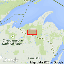
Type area: exposures in the vicinity of Blair Creek, in T. 46 N., R. 40 and 41 W., [Thayer 15-min quadrangle, Ontonogan and Gogebic Cos., Ottawa National Forest], Northern Peninsula, MI.
Additional exposures: (1) Barb Lake area, in secs. 1 through 6, T. 45 N., R. 42 W., [Gogebic 7.5-min quadrangle, Gogebic Co.]; (2) in vicinity of Marenisco [Gogebic Co.]; and (3) narrow belt in overturned southeast limb of Copps syncline [btw. Pelton Pond and Cup Lake], extending from sec. 30, T. 46 N., R. 42 W., into sec. 7, T. 46 N., R. 41 W. [Gogebic and Cup Lake 7.5-min quadrangles, Gogebic Co.].
[Additional locality information from USGS historical topographic map collection TopoView, accessed on June 9, 2017.]
Source: Publication; US geologic names lexicon (USGS Bull. 1565, p. 34).
For more information, please contact Nancy Stamm, Geologic Names Committee Secretary.
Asterisk (*) indicates published by U.S. Geological Survey authors.
"No current usage" (†) implies that a name has been abandoned or has fallen into disuse. Former usage and, if known, replacement name given in parentheses ( ).
Slash (/) indicates name conflicts with nomenclatural guidelines (CSN, 1933; ACSN, 1961, 1970; NACSN, 1983, 2005, 2021). May be explained within brackets ([ ]).