The National Geologic Map Database is migrating to a new infrastructure. We apologize for any service disruptions during this process.
|
|---|


- Usage in publication:
-
- Blacktail Deer Creek formation, basalts
- Modifications:
-
- Revised
- AAPG geologic province:
-
- Montana folded belt
Summary:
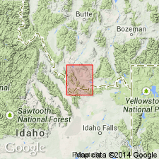
Name Blacktail Deer Creek basalts applied to several basalt flows associated with the Blacktail Deer Creek formation of early Miocene age. The basalts are mapped at northeast edge of map (geologic map) in Beaverhead and Madison Cos, MT in the Montana folded belt province, northeast of Blacktail Deer Creek. They have a dark, locally vesicular groundmass with phenocrysts of feldspar. Small crystals of augite seen in thin section. Similar basalts occur elsewhere in mapped area as small remnants attesting to a greater extent in the Blacktail, Ruby, and Snowcrest Ranges. Assigned a Miocene age; younger than Medicine Lodge volcanics and older than Edie School rhyolites.
Source: GNU records (USGS DDS-6; Denver GNULEX).
For more information, please contact Nancy Stamm, Geologic Names Committee Secretary.
Asterisk (*) indicates published by U.S. Geological Survey authors.
"No current usage" (†) implies that a name has been abandoned or has fallen into disuse. Former usage and, if known, replacement name given in parentheses ( ).
Slash (/) indicates name conflicts with nomenclatural guidelines (CSN, 1933; ACSN, 1961, 1970; NACSN, 1983, 2005, 2021). May be explained within brackets ([ ]).