The National Geologic Map Database is migrating to a new infrastructure. We apologize for any service disruptions during this process.
|
|---|


- Usage in publication:
-
- Black Rock Volcanics
- Modifications:
-
- Geochronologic dating
- AAPG geologic province:
-
- Basin-and-Range province
Summary:
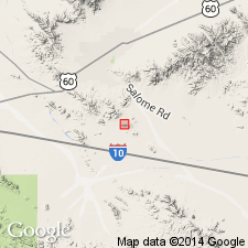
Sample of gray, medium-grained, undeformed to mildly foliated, porphyritic rhyolite to rhyodacite have similar U-Pb and Th-Pb dates of 156 to 165 Ma, but Pb-Pb dates of 174 to 236 Ma. Emplacement age is about 160 Ma. Occurs in the Little Harquahala Mountains of La Paz Co, AZ in the Basin-and-Range province.
Source: GNU records (USGS DDS-6; Denver GNULEX).
- Usage in publication:
-
- Black Rock volcanics
- Modifications:
-
- First used
- Dominant lithology:
-
- Porphyry
- Tuff
- AAPG geologic province:
-
- Basin-and-Range province
Summary:
First published use of name for some volcanic rocks in the Harquar plate in the low hills in the southernmost part of the Little Harquahala and western Harquahala Mountains, La Paz Co, AZ in the Basin-and-Range province. Intent to name, source of geographic name, designation of a type not stated; [term probably? considered informal by author.] Consists of massive, intrusive, or extrusive quartz-feldspar porphyry and lithic sandstone derived from the porphyry. Also includes rhyolitic to andesitic flows, ash-flow tuff, probable hypabyssal intrusions, and volcaniclastic rocks. Internal stratigraphy cannot be resolved because of discontinuous exposures. Has a gradational contact over 2-3 m with the underlying porphyritic monzogranite suggesting these two rock types are cogenetic. Stratigraphic diagrams. Is overlain depositionally by Ranegras member (first used) of McCoy Mountains Formation. Geologic maps. U-Pb isotopic evidence [not included in this report] gives a late Middle to early Late Jurassic age.
Source: GNU records (USGS DDS-6; Denver GNULEX).
For more information, please contact Nancy Stamm, Geologic Names Committee Secretary.
Asterisk (*) indicates published by U.S. Geological Survey authors.
"No current usage" (†) implies that a name has been abandoned or has fallen into disuse. Former usage and, if known, replacement name given in parentheses ( ).
Slash (/) indicates name conflicts with nomenclatural guidelines (CSN, 1933; ACSN, 1961, 1970; NACSN, 1983, 2005, 2021). May be explained within brackets ([ ]).