

- Usage in publication:
-
- Black Prairie series
- Modifications:
-
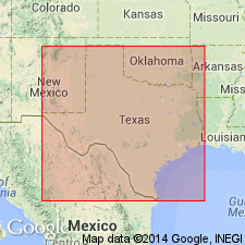
- Areal extent
- AAPG geologic province:
-
- Arkla basin
- East Texas basin
- Ouachita folded belt
Summary:
Pg. xiii-xiv. Upper Cretaceous or Black Prairie series, a local name for the Upper Cretaceous deposits of Texas and southwestern Arkansas
Source: US geologic names lexicon (USGS Bull. 896, p. 204-205).

- Usage in publication:
-
- Black Prairie series†
- Modifications:
-
- Overview
- AAPG geologic province:
-
- Arkla basin
- East Texas basin
- Ouachita folded belt
Summary:
†Black Prairie series. Same as Gulf series, older name.
Named from Black Prairie of eastern TX and AR defined by R.T. Hill in Amer. Jour. Sci., 3rd ser., v. 33, p. 294, 1887.
Source: US geologic names lexicon (USGS Bull. 896, p. 204-205).
For more information, please contact Nancy Stamm, Geologic Names Committee Secretary.
Asterisk (*) indicates published by U.S. Geological Survey authors.
"No current usage" (†) implies that a name has been abandoned or has fallen into disuse. Former usage and, if known, replacement name given in parentheses ( ).
Slash (/) indicates name conflicts with nomenclatural guidelines (CSN, 1933; ACSN, 1961, 1970; NACSN, 1983, 2005, 2021). May be explained within brackets ([ ]).