The National Geologic Map Database is migrating to a new infrastructure. We apologize for any service disruptions during this process.
|
|---|


- Usage in publication:
-
- Black Point member
- Modifications:
-
- Original reference
- Dominant lithology:
-
- Marble
- AAPG geologic province:
-
- Northern Rocky Mountain region
Summary:
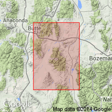
Pg. 7. Black Point member of Cherry Creek series. Name suggested for dolomitic marble occurring in Cherry Creek series. Weathers to dirty-brown granular surfaces which look dark in distance. Bedding at Black Point nearly vertical. Repetition of beds, either by folding or faulting, may account for the 1.5 mile width of the outcrop.
[Type area]: in area about 5 mi long and 1.5 mi wide, between Johnny Gulch and Cherry Creek, Madison Co., MT. Marble forms conspicuous ridge known locally as Black Point.
["Cherry Creek series" considered informal. The practice of employing "Series" for lithostratigraphic or lithodemic nomenclature is now regarded as improper. Term "Series" is applied formally only to chronostratigraphic units (ACSN, 1961, 1970; NACSN, 1983, 2005, 2021).]
Source: US geologic names lexicon (USGS Bull. 1200, p. 370-371).
For more information, please contact Nancy Stamm, Geologic Names Committee Secretary.
Asterisk (*) indicates published by U.S. Geological Survey authors.
"No current usage" (†) implies that a name has been abandoned or has fallen into disuse. Former usage and, if known, replacement name given in parentheses ( ).
Slash (/) indicates name conflicts with nomenclatural guidelines (CSN, 1933; ACSN, 1961, 1970; NACSN, 1983, 2005, 2021). May be explained within brackets ([ ]).