

- Usage in publication:
-
- Black Lion Conglomerate*
- Modifications:
-
- Named
- Dominant lithology:
-
- Conglomerate
- AAPG geologic province:
-
- Montana folded belt
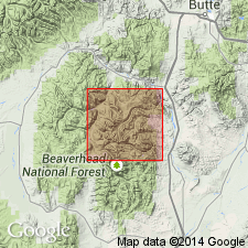
Summary:
Named for exposures on cliffs between Black Lion Mountain and top of talus above Black Lion Lake at 9,000 ft elevation, Vipond Park quad, Beaverhead Co, MT in Montana folded belt province. These exposures are also the type section. Is composed of conglomerate and minor interbedded quartzite. Conglomerate is in beds about 1 m thick and in trough cross-bedded sets about 10 cm thick. Clasts are mostly quartz, matrix supported, well to poorly sorted, medium to poorly rounded. Some silty quartzite clasts resemble Middle Proterozoic rocks. Some clasts of feldspar concentrated in layers. Cross bedding is nearly ubiquitous. Is at least 500 m thick. Lower contact not exposed; upper contact gradational with lower member of Silver Hill Formation. May correlate with Tintic Quartzite of UT and with Cash Creek Quartzite of ID. Nonfossiliferous; age limited by age of overlying unit. Assigned to the Cambrian? and Cambrian.
Source: GNU records (USGS DDS-6; Denver GNULEX).
- Usage in publication:
-
- Black Lion Conglomerate
- Modifications:
-
- Not used
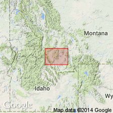
Summary:
In Pioneer Mountains, rocks named Black Lion Conglomerate of Cambrian? and Cambrian age mapped in this report as an unnamed Middle Proterozoic? conglomerate in the Belt Supergroup. This unit of gray, matrix-supported pebble conglomerate, pebbly quartzite and poorly sorted, argillaceous quartzite and sandstone grit is considered to be similar to parts of the LaHood Formation of the Belt Supergroup in the Highland Mountains, MT east of the Pioneer Mountains. Name Black Lion not used.
Source: GNU records (USGS DDS-6; Denver GNULEX).
For more information, please contact Nancy Stamm, Geologic Names Committee Secretary.
Asterisk (*) indicates published by U.S. Geological Survey authors.
"No current usage" (†) implies that a name has been abandoned or has fallen into disuse. Former usage and, if known, replacement name given in parentheses ( ).
Slash (/) indicates name conflicts with nomenclatural guidelines (CSN, 1933; ACSN, 1961, 1970; NACSN, 1983, 2005, 2021). May be explained within brackets ([ ]).