The National Geologic Map Database is migrating to a new infrastructure. We apologize for any service disruptions during this process.
|
|---|


- Usage in publication:
-
- Black Dyke Formation
- Modifications:
-
- Named
- Geochronologic dating
- Dominant lithology:
-
- Breccia
- Volcanics
- AAPG geologic province:
-
- Great Basin province
Summary:
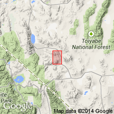
Named for mountain in east Garfield Hills. Type area: Black Dyke Mountain, east Garfield Hills, Mineral Co, NV. Consists of mafic volcanic breccia with minor intercalated volcanogenic sedimentary rocks, lavas, and intrusive rocks. Is allochthonous thrust nappe, uppermost in nappe pile of Luning allochthon. Overlies, in thrust-fault contact, Triassic and Jurassic sedimentary rocks; unconformably underlies Tertiary volcanics intruded by Late Cretaceous(?) granitic rocks. Is Permian age on basis of K-Ar determination on hornblende phenocrysts from central Excelsior Mountains of 253 +/-3 and 252 +/-3 Ma.
Source: GNU records (USGS DDS-6; Menlo GNULEX).
For more information, please contact Nancy Stamm, Geologic Names Committee Secretary.
Asterisk (*) indicates published by U.S. Geological Survey authors.
"No current usage" (†) implies that a name has been abandoned or has fallen into disuse. Former usage and, if known, replacement name given in parentheses ( ).
Slash (/) indicates name conflicts with nomenclatural guidelines (CSN, 1933; ACSN, 1961, 1970; NACSN, 1983, 2005, 2021). May be explained within brackets ([ ]).