The National Geologic Map Database is migrating to a new infrastructure. We apologize for any service disruptions during this process.
|
|---|


- Usage in publication:
-
- Bitterwater Creek shale
- Modifications:
-
- Original reference
- Dominant lithology:
-
- Shale
- AAPG geologic province:
-
- Coastal basins
- San Joaquin basin
Summary:
Pg. 8, 10 (fig. 5), 11 (fig. 6), pl. 1. Bitterwater Creek shale. Coarse upper Miocene breccias of southwest flank of Temblor Range are overlain unconformably(?) by sequence of Pliocene(?) age. In south end of range, from Elkhom Hills southeastward across upper Bitterwater Creek, this unit is indistinctly bedded brown semisiliceous shale commonly referred to as "Santa Margarita" shale. It is herein named Bitterwater Creek shale. Thickness about 2,000 feet at type locality. Overlies Santa Margarita conglomerate and sandstone. Unconformably underlies Paso Robles formation. Grades laterally into Panorama Hills formation (new). Age is Pliocene(?).
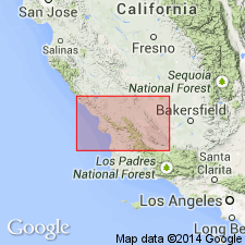
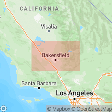
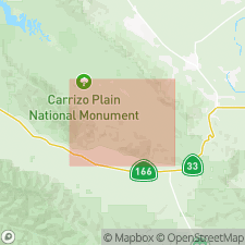
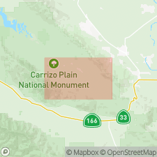
Type locality: Bitterwater Creek, on southwest flank of Temblor Range, 6 mi southwest of Maricopa, in secs. 32 and 33, T. 11 N., R. 24 W., [bdry. btw. Ballinger Canyon and Maricopa 7.5-min quadrangles], Kern Co., central CA.
Source: US geologic names lexicon (USGS Bull. 1350, p. 71-72); GNU records (USGS DDS-6; Menlo GNULEX).
- Usage in publication:
-
- Bitterwater Creek shale
- Modifications:
-
- Areal extent
- AAPG geologic province:
-
- Coastal basins
- San Joaquin basin
Summary:
Bitterwater Creek Shale. Indistinctly bedded brown semisiliceous shale grading northwesterly through marine sandstone into nonmarine gravels of Panorama Hills Formation. Mapped with middle and (or) lower Pliocene marine sedimentary rocks [alaong southern boundary of map sheet]. Formerly mapped as Santa Margarita Shale.
Source: Publication; US geologic names lexicon (USGS Bull. 1350, p. 71-72).
- Usage in publication:
-
- Bitterwater Creek Shale of Dibblee (1962)*
- Modifications:
-
- Age modified
- Mapped
- AAPG geologic province:
-
- Coastal basins
- San Joaquin basin
Summary:
Bitterwater Creek Shale of Dibblee (1962). Clayey siltstone and silty claystone, pale-olive to greenish-gray, weathers to white, indistinctly bedded to thin-bedded, concretionary; shattered and contorted near San Andreas fault zone. Marine. Lies below Pleistocene Paso Robles Formation of Dibblee (1962) and above Miocene(?) and Pliocene(?) unnamed siltstone unit. Age is considered Miocene(?) and Pliocene(?).
[Notable exposures north of San Andreas fault zone, in T. 12 N., R. 25 and 26 W., northern part of map sheet.]
Source: Publication; US geologic names lexicon (USGS Bull. 1350, p. 71-72).
- Usage in publication:
-
- Bitterwater Creek Shale of Dibblee (1962)*
- Modifications:
-
- Age modified
- Mapped
- AAPG geologic province:
-
- Coastal basins
Summary:
Bitterwater Creek Shale of Dibblee (1962). Lies above Miocene Santa Margarita Formation and below Pliocene(?) and Pleistocene(?) Paso Robles(?) Formation. Age is considered Miocene. [Mapped in northern part of map sheet, northeast of San Andreas fault zone and southwest of Recruit Pass fault, San Luis Obispo Co.] Mapped subdivisions:
(1) Silty claystone and clayey siltstone (Tbw) [main part], semi-siliceous, pale-brown or yellowish-brown to pale-olive or greenish-gray, weathers to white or pale yellowish gray, indistinctly bedded to thin-bedded; breaks with a hackly or splintery fracture; concretionary at places; locally includes thin lenses of shale-pebble-conglomerate. [Thickness not stated.] Marine. Fossils; contains diatoms and fish scales that indicate a late Miocene age; upper part may be Pliocene in age.
(2) Sandstone and shale-pebble conglomerate (Tbws), pale-yellowish-brown to yellowish-gray, lenticular to thick-bedded; contains thin lenses of siltstone and claystone at places and well-rounded clasts of granitic and sedimentary rocks in upper part. [Thickness not stated.] Marine. Uppermost part may include beds of Pliocene age.
(3) Tar-saturated sandstone and conglomerate (Tbwt) [in lower part of formation], lenticular, intertongues with (Tbw). [Thickness not stated.]
Source: Publication.
- Usage in publication:
-
- Bitterwater Creek Shale*
- Modifications:
-
- Age modified
- Adopted
- AAPG geologic province:
-
- Coastal basins
- San Joaquin basin
Summary:
Pg. 15 (fig. 8), 33. Bitterwater Creek Shale of Dibblee (1962) is herein adopted by the USGS. Relationship of Bitterwater Creek Shale to unnamed Pliocene marine clastic sediments to northwest which were formerly included in Bitterwater Creek Shale (Dibblee, 1962) is not clear because of insufficient exposures and structural complications. Disconformably(?) overlies Santa Margarita Formation; unconformably underlies Paso Robles Formation. Formation yielded foraminifers, fish scales, and diatoms of late Miocene (Mohnian) age (R.L. Pierce, oral commun., 1967; Vedder, 1970). From foregoing evidence, Bitterwater Creek Shale is considered to be late Miocene (Mohnian) and possibly early Pliocene in age.
Source: GNU records (USGS DDS-6; Menlo GNULEX); Changes in stratigraphic nomenclature, 1973 (USGS Bull. 1395-A, p. A6-A7).
For more information, please contact Nancy Stamm, Geologic Names Committee Secretary.
Asterisk (*) indicates published by U.S. Geological Survey authors.
"No current usage" (†) implies that a name has been abandoned or has fallen into disuse. Former usage and, if known, replacement name given in parentheses ( ).
Slash (/) indicates name conflicts with nomenclatural guidelines (CSN, 1933; ACSN, 1961, 1970; NACSN, 1983, 2005, 2021). May be explained within brackets ([ ]).