

- Usage in publication:
-
- Big Skunk Formation
- Modifications:
-
- Named
- Dominant lithology:
-
- Mudstone
- Shale
- Sandstone
- Tuff
- Breccia
- Conglomerate
- AAPG geologic province:
-
- Montana folded belt
Summary:
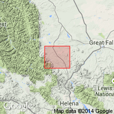
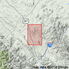
Named as formation (in Montana Group) for Big Skunk Creek, major tributary, Middle Fork, Dearborn River; type section measured in road cuts along MT State Hwy 20, NE1/4, SW1/4 sec 21, T17N, R5W, Lewis and Clark Co, MT, Montana folded belt province. Unit generally restricted to that part of Disturbed belt south of Sun River and west of Adel Mountain volcanic field; intertongues eastward with Two Medicine Formation, Montana Group, along eastern edge of Disturbed belt; bounded on west by overthrusted Precambrian and Paleozoic strata; and extends south to Big Belt Mountains. Composed mostly of volcanic-rich sedimentary rocks (mudstone, shale, sandstone, breccia, and conglomerate) with some interbedded tuff. Is 2,113 ft thick at measured type section and is divided into 5 informal members (A-E): A member (185 ft), mostly grayish red sandy mudstone and grayish red to olive-gray sedimentary breccia; B member (121 ft), grayish red or dark greenish gray ash-flow tuff; C member (611 ft), highly variable volcanic-rich lithologic units including mudstone, shale, limestone, clay, sandstone, and conglomerate; D member (645 ft), mostly olive-gray to greenish black, friable, volcanic-rich sandy mudstone interbedded with sandstone; E member (538 ft), mostly light gray-green shaly mudstone and olive-gray and gray-green sandstone and shale. Overlies Two Medicine Formation; underlies St. Mary River Formation. Detailed descriptions. Late Cretaceous age.
Source: GNU records (USGS DDS-6; Denver GNULEX).
- Usage in publication:
-
- Big Skunk Formation*
- Modifications:
-
- Overview
- AAPG geologic province:
-
- Montana folded belt
Summary:
Same as volcanic member in western facies Two Medicine Formation. Volcanic member mapped as 4 map units in eastern Lewis and Clark Co, MT, Montana folded belt province. Mapped units described as (ascending): 1) clastic volcanic rocks--green, grayish-green, gray, brownish-gray volcanic sandstone, siltstone, mudstone; sandstones medium to coarse grained, thick-bedded, cross-bedded, locally conglomeratic; 400 ft thick; 2) latite flows--gray, grayish-purple, brown-weathered; massive, porphyritic; composed of labradorite, andesine, sanidine, augite, biotite, magnetite; has 2 separate flows with abundant small amygdules of calcite, zeolites, celadonite at tops; 550 ft thick; 3) ash-flow tuffs--alternating zones green, grayish-green, tan, red, grayish-red rubbly pumiceous tuff and red, purple, brown densely welded tuff; rhyolitic, dacitic; has devitrified glass shards, devitrified pumice fragments, crystals of andesine, labradorite, biotite, augite, magnetite; includes 3 separate tuff sheets; 475 ft thick; 4) clastic volcanic rocks--maroon, reddish-purple, grayish-purple, dark-greenish-gray, grayish-green, green volcanic sandstone, siltstone, mudstone, a few thin beds of white to pink ash-fall tuff; sandstones medium to coarse grained, thick-bedded, cross-bedded, locally conglomeratic with rounded clasts andesite, latite, welded rhyolitic tuff as much as a ft across; about 100 ft maximum thickness in this quad. Late Cretaceous age.
Source: GNU records (USGS DDS-6; Denver GNULEX).
For more information, please contact Nancy Stamm, Geologic Names Committee Secretary.
Asterisk (*) indicates published by U.S. Geological Survey authors.
"No current usage" (†) implies that a name has been abandoned or has fallen into disuse. Former usage and, if known, replacement name given in parentheses ( ).
Slash (/) indicates name conflicts with nomenclatural guidelines (CSN, 1933; ACSN, 1961, 1970; NACSN, 1983, 2005, 2021). May be explained within brackets ([ ]).