The National Geologic Map Database is migrating to a new infrastructure. We apologize for any service disruptions during this process.
|
|---|


- Usage in publication:
-
- Bieroth Andesite
- Modifications:
-
- Named
- Dominant lithology:
-
- Andesite
- Tuff
- AAPG geologic province:
-
- Great Basin province
Summary:
Pg. 22, pI. 1 (geol. map). Bieroth Andesite. Consists of tuffs and andesites, welded tuffs, and flows. Rocks are light-brownish gray to yellowish gray and pinkish gray on fresh surface, darker on weathered surface. Small euhedral biotite scattered throughout rock. Total thickness of flows and pyroclastics about 200 to 400 feet. On Sunflower Flat the Bieroth is nearly horizontal and grades conformably upward into Jarbridge Rhyolite. In northern part of quadrangle dips about 20 degrees north and unconformably by Idavada Volcanics. Unconformably overlies Paleozoic rocks including Tennessee Mountain Formation, unnamed Paleozoic metamorphic rocks, and Diamond A Formation (new). Age is considered to be Miocene, based on stratigraphic position. [Age is Eocene(?) on map legend.] Report includes geologic map, cross sections.
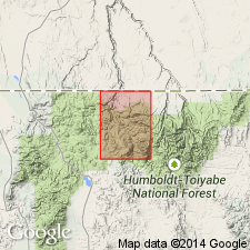
Type locality not designated. Named from exposures around Bieroth Spring, in sec. 14, T. 45 N., R. 55 E., Rowland quadrangle, Elko Co., northern NV. Unit has a low, subdued topography; also exposed along Big Bend Creek southeast of Sunflower Reservoir, along Bruneau River north of McDonald Creek, between Taylor Creek and Long Canyon, and on north side of Bearpaw Mountain.
Source: US geologic names lexicon (USGS Bull. 1350, p. 64); GNU records (USGS DDS-6; Denver GNULEX).
- Usage in publication:
-
- Bieroth volcanics
- Modifications:
-
- Redescribed
- Revised
- Age modified
- Areal extent
- Dominant lithology:
-
- Rhyodacite
- Quartz latite
- AAPG geologic province:
-
- Snake River basin
Summary:
Redescribed from andesite to rhyodacite or quartz latite based on chemical composition. Extended into upper Sheep Creek drainage area, south-central Owyhee County, Idaho, Snake River basin. [Rank of unit not specified; not clear if used as formal or informal unit]. Divided into three [unranked] units, in ascending order: Alder Creek tuff (first published use), Cedar Canyon tuff (new), and volcanic neck at Browns Basin. Unconformably overlies Cretaceous biotite granodiorite of Cottonwood Creek pluton; underlies various volcanic units of Miocene age. Age is Eocene, based on correlation with similar units radiometrically dated in Jarbidge Mountains (40.9 m.y.; citing Coats, 1964) and in Poison Creek area of northern Owyhee County (44.7 m.y.; citing Armstrong and others, 1980).
Source: Modified from GNU records (USGS DDS-6; Denver GNULEX).
For more information, please contact Nancy Stamm, Geologic Names Committee Secretary.
Asterisk (*) indicates published by U.S. Geological Survey authors.
"No current usage" (†) implies that a name has been abandoned or has fallen into disuse. Former usage and, if known, replacement name given in parentheses ( ).
Slash (/) indicates name conflicts with nomenclatural guidelines (CSN, 1933; ACSN, 1961, 1970; NACSN, 1983, 2005, 2021). May be explained within brackets ([ ]).