

- Usage in publication:
-
- Beulah clay*
- Modifications:
-
- Revised
- Overview
- Areal extent
- AAPG geologic province:
-
- Powder River basin
- Williston basin
- Chadron arch
Summary:
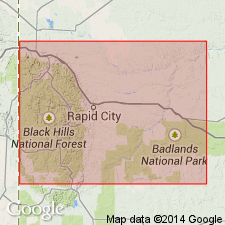
First appears [on east side of the Black Hills] northeast of Hermosa, Custer Co, SD, on Chadron arch, lying between Unkpapa sandstone (new) and Lakota formation (new). Thickens rapidly northward and passes around the northern and western sides of the Black Hills [SD and WY, in Williston and Powder River basins]. Beyond the edge of Unkpapa sandstone, lies conformably on Sundance formation. Is Jurassic in age.
Source: GNU records (USGS DDS-6; Denver GNULEX).
- Usage in publication:
-
- Beulah clay*
- Modifications:
-
- Original reference
- Biostratigraphic dating
- Dominant lithology:
-
- Claystone
- Sandstone
- Shale
- AAPG geologic province:
-
- Powder River basin
Summary:
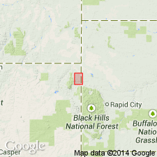
Pg. 593, fig. 122, map. Beulah clays. Upper Jurassic fresh or brackish water deposits. In Hay Creek coal field, Crook County, northeastern Wyoming, consist of: (1) ATLANTOSAURUS beds, 25 to 35 feet of whitish and light-gray clays with some sandy shales and concretions of white calcareous clay, the upper layers in many localities carrying fossil wood and the bones of saurians; (2) light-gray, thin-bedded sandstone, 5 to 10 feet. Underlie Hay Creek coal formation with greatest unconformity in section, and unconformably overlie Lower Jurassic marine beds. Long outcrops of these clays occur 3 or 4 miles north of Beulah, in Red Water Valley [Crook County, northeastern Wyoming].
[Recognized in Black Hills area, northeastern WY and western SD.]
Source: US geologic names lexicon (USGS Bull. 896, p. 177).
- Usage in publication:
-
- Beulah shale*
- Modifications:
-
- Not used
Summary:
Substitutes Morrison formation for rocks formerly known as the "Atlantosaurus beds" and Beulah shale [clays] in the Black Hills region, WY and SD.
Source: GNU records (USGS DDS-6; Denver GNULEX).
For more information, please contact Nancy Stamm, Geologic Names Committee Secretary.
Asterisk (*) indicates published by U.S. Geological Survey authors.
"No current usage" (†) implies that a name has been abandoned or has fallen into disuse. Former usage and, if known, replacement name given in parentheses ( ).
Slash (/) indicates name conflicts with nomenclatural guidelines (CSN, 1933; ACSN, 1961, 1970; NACSN, 1983, 2005, 2021). May be explained within brackets ([ ]).