The National Geologic Map Database is migrating to a new infrastructure. We apologize for any service disruptions during this process.
|
|---|


- Usage in publication:
-
- Bethany formation
- Modifications:
-
- Areal extent
- Dominant lithology:
-
- Silt
- Clay
- Sand
- AAPG geologic province:
-
- Atlantic Coast basin
Summary:
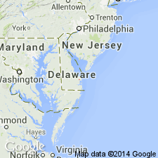
Bethany formation is an informal lithostratigraphic unit of late Miocene or early Pliocene age. In Well Oh25-02, 3 mi south of Lewes, DE, unit occurs at a depth interval of 119 to 173 ft and consists of unconsolidated, olive-gray, soft, sandy silt and clay with a few 4- to 10-ft thick silt and sand beds. Unit becomes sandier elsewhere in southeastern Sussex Co. Contains lignitized and pyritized plant remains. Unconformably underlies Beaverdam Formation and overlies informal Manokin formation.
Source: GNU records (USGS DDS-6; Reston GNULEX).
- Usage in publication:
-
- Bethany formation
- Modifications:
-
- Biostratigraphic dating
- AAPG geologic province:
-
- Atlantic Coast basin
Summary:
Bethany formation (informal), uppermost unit of Chesapeake Group is described as a lithologically heterogeneous unit of gray, olive gray, and bluish-gray clay or silt interbedded with bluish-gray or olive gray, fine to very coarse sand. Lignitic and gravelly beds are common. Contact with the underlying Manokin formation (informal) is here further defined as the base of the first clay or silt greater than 5 ft in thickness above the well-developed sand of the Manokin B. Contact is gradational to sharp. Updip Bethany loses its characteristic clayey nature and cannot be differentiated from overlying Beaverdam Formation of the Columbia Group. Pollen assemblages similar to those of the Brandywine and Eastover Formations indicate an age of late Miocene or early Pliocene.
Source: GNU records (USGS DDS-6; Reston GNULEX).
- Usage in publication:
-
- Bethany Formation
- Modifications:
-
- Original reference
- Dominant lithology:
-
- Clay
- Silt
- AAPG geologic province:
-
- Atlantic Coast basin
Summary:
Pg. 6-7. Bethany Formation [of Chesapeake Group]. Occurs only in subsurface. Is a sequence of clayey and silty beds with discontinuous lenses of quartzose sand. Apparent thickness about 195 feet. Lies above Cat Hill Formation (new; replaces †"Manokin formation") and below Beaverdam Formation. Replaces Andres' (1986) "Bethany formation." Includes Pocomoke aquifer. Extends into Maryland where it includes the Ocean City aquifer. Age is considered late middle Miocene (Owens and Denny, 1979; Hansen, 1981; Benson, 1990) to perhaps Pliocene (Miller and others, 2003). Age poorly constrained due to general lack of diagnostic fossils or other materials that can be age-dated.
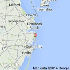
Type locality (subsurface; composite): 2 drillholes near Bethany Beach, Bethany Beach 7.5-min quadrangle, eastern Sussex Co., southern DE: (1) depth-interval 125 to 320 ft, DGS drillhole Qj32-14, Lat. 38 deg. 32 min. 15 sec. N., Long. 75 deg. 03 min. 17 sec. W.; and (2) depth-interval 118 to 313 ft, DGS corehole Qj32-27, Lat. 38 deg. 32 min. 53 sec. N., Long. 75 deg. 03 min. 45 sec. W.
Reference sections (subsurface):
(1) depth-interval 119 to 173 ft, DGS borehole Oh25-02, Lat. 38 deg. 43 min. 50 sec. N., Long. 75 deg. 10 min. 14 sec. W.;
(2) depth-interval 95 to 180 ft, DGS borehole Pg53-14, Lat. 38 deg. 35 min. 24 sec. N., Long. 75 deg. 17 min. 42 sec. W.;
(3) depth-interval 125 to 320 ft, DGS drillhole Qj32-14, Lat. 38 deg. 32 min. 15 sec. N., Long. 75 deg. 03 min. 17 sec. W.; and
(4) depth-interval 130 to 315 ft, DGS borehole Qj41-04, Lat. 38 deg. 31 min. 22 sec. N., Long. 75 deg. 04 min. 05 sec. W.
Source: Publication.
For more information, please contact Nancy Stamm, Geologic Names Committee Secretary.
Asterisk (*) indicates published by U.S. Geological Survey authors.
"No current usage" (†) implies that a name has been abandoned or has fallen into disuse. Former usage and, if known, replacement name given in parentheses ( ).
Slash (/) indicates name conflicts with nomenclatural guidelines (CSN, 1933; ACSN, 1961, 1970; NACSN, 1983, 2005, 2021). May be explained within brackets ([ ]).