

- Usage in publication:
-
- Berry conglomerate
- Modifications:
-
- Named
- Dominant lithology:
-
- Conglomerate
- Sandstone
- Redbeds
- AAPG geologic province:
-
- Coastal basins
Summary:
Pg. 464 (fig. 190), 465; Thorup, 1941 [abs.], GSA Bull., v. 52, no. 12, pt. 2, p. 1958. Berry conglomerate. Conglomeratic sandstone of probable continental origin; is usually white, poorly sorted and poorly bedded, angular to subrounded, friable, commonly stained brown on weathered surfaces; red beds are in upper part, and boulder beds are common. Thickness 1,100 feet. Disconformably overlies The Rocks sandstone (new). Appears to grade into overlying Vaqueros formation; contact of two placed at lowest of finer-grained sandstone. No fossils were found. Age is Oligocene, based on stratigraphic relations. [Oligocene(?) age on map legend.]
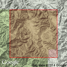
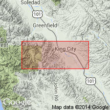
Type locality: in upper Reliz Canyon, on west side of Salinas Valley, in SE/4 sec. 26, T. 20 S., R. 6 E., [Reliz Canyon 7.5-min quadrangle, Los Padres National Forest], Monterey Co., western central CA. Named from typical exposures near Berry Ranch [shown in SW/4 NW/4 sec. 26, T. 20 S., R. 6 E., approx. Lat. 36 deg. 09 min. 43 sec. N., Long. 121 deg. 17 min. 34 sec. W., Junipero Serra 15-min quadrangle (1930 and previous ed.).]
[Additional locality information from USGS historical topographic map collection TopoView, accessed August 18, 2017.]
Source: US geologic names lexicon (USGS Bull. 1200, p. 314-315); GNU records (USGS DDS-6; Menlo GNULEX).
- Usage in publication:
-
- Berry formation*
- Modifications:
-
- Redescribed
- Age modified
- Adopted
- AAPG geologic province:
-
- Coastal basins
Summary:
Berry conglomerate of Thorup (1943) is adopted by the USGS as Berry formation. Is widespread. Underlies marine Vaqueros sandstone; unconformably overlies older rocks. Not separately mapped from Vaqueros south of Antonio River. Age may be Eocene to early Miocene and may vary in different areas.
Source: GNU records (USGS DDS-6; Menlo GNULEX).
- Usage in publication:
-
- Berry Formation†
- Modifications:
-
- Abandoned
- AAPG geologic province:
-
- Coastal basins
Summary:
Term Berry Formation not used in this report which includes its type locality; its rocks are mapped as the lower unnamed member of the Vaqueros Formation. [In essence, this abandons the Berry Formation].
Source: GNU records (USGS DDS-6; Menlo GNULEX).
- Usage in publication:
-
- Berry Formation*
- Modifications:
-
- Reinstated
- Age modified
- AAPG geologic province:
-
- Coastal basins
Summary:
Because beds are distinct, they are here considered a formation. Here restricted to beds in stratigraphic context of type locality, i.e., beds that lie between Reliz Canyon Formation and Vaqueros Formation. Geologic sketch map shows distribution in surface and subsurface in Junipero Serra Peak, Reliz Canyon, Bear Canyon, and Cosio Knob 7.5' quads. Unit is chiefly conglomerate and conglomeratic sandstone with fine-grained sandstone and mudstone. Is generally 600 to 1500 ft thick. Although Berry could be as old as Eocene or as young as Miocene, unit is assigned Oligocene(?) age based on stratigraphic position.
Source: GNU records (USGS DDS-6; Menlo GNULEX).
For more information, please contact Nancy Stamm, Geologic Names Committee Secretary.
Asterisk (*) indicates published by U.S. Geological Survey authors.
"No current usage" (†) implies that a name has been abandoned or has fallen into disuse. Former usage and, if known, replacement name given in parentheses ( ).
Slash (/) indicates name conflicts with nomenclatural guidelines (CSN, 1933; ACSN, 1961, 1970; NACSN, 1983, 2005, 2021). May be explained within brackets ([ ]).