The National Geologic Map Database is migrating to a new infrastructure. We apologize for any service disruptions during this process.
|
|---|


- Usage in publication:
-
- Benton Run Mudstone
- Modifications:
-
- Named
- Dominant lithology:
-
- Mudstone
- AAPG geologic province:
-
- Appalachian basin
Summary:
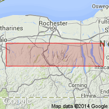
Highest division of Jaycox Member of Ludlowville Formation is here designated Benton Run Mudstone for exposures along the main channel of Benton Run at Seneca Lake, western NY. Unit is present from Hill's Gulch eastward into the central Finger Lakes region and consists of sparsely fossiliferous, calcareous, silty gray siliciclastic mudstone. Contains only a few brachiopods and other fauna in contrast to the underlying Cottage City Coral Beds (new). Bed thickens eastward from 5 cm at Hill's Gulch to 55 cm at the west shore of Canandaigua Lake and southward to 7.4 m at Kashong Glen, 4 km south of Benton Run. Thickness at type is 5.0 m. Underlies the Tichenor Member of the Moscow Formation. Age is Middle Devonian.
Source: GNU records (USGS DDS-6; Reston GNULEX).
For more information, please contact Nancy Stamm, Geologic Names Committee Secretary.
Asterisk (*) indicates published by U.S. Geological Survey authors.
"No current usage" (†) implies that a name has been abandoned or has fallen into disuse. Former usage and, if known, replacement name given in parentheses ( ).
Slash (/) indicates name conflicts with nomenclatural guidelines (CSN, 1933; ACSN, 1961, 1970; NACSN, 1983, 2005, 2021). May be explained within brackets ([ ]).